Rowan County Forecast: Storm Chances Return This Weekend, Heat Builds Next Week
Good Friday morning! Here's my latest forecast for Rowan County.
After a couple of relatively quiet afternoons, we're beginning to see a more typical summertime weather pattern return. While today won't be a washout by any means, you'll want to keep an eye on the sky later this afternoon and evening as isolated thunderstorms begin to develop. That pattern will continue through the weekend, with a few storms capable of becoming strong.
Today
We'll enjoy another warm summer day with a mix of sunshine and clouds. High temperatures will reach around 89 degrees. A 20% chance of showers and thunderstorms develops after 2 PM, but many locations will stay dry. Any storms that do form will be brief but could produce heavy rain and gusty winds.
Tonight, a few lingering showers or thunderstorms remain possible before 9 PM. Skies gradually become partly cloudy with overnight lows around 70 degrees.
Saturday
Saturday brings a little more moisture into the atmosphere, which means a better opportunity for scattered afternoon and evening thunderstorms. Highs climb to around 92 degrees with a 30% chance of storms after 3 PM.
While not everyone will see rain, a few storms could become strong during the afternoon and evening. Gusty winds, frequent lightning, and heavy downpours will be the primary threats. I'll be monitoring trends closely throughout the day.
Saturday night brings another chance for thunderstorms before midnight before skies partially clear.
Sunday
Heat continues to build with afternoon highs reaching around 94 degrees. Storm chances remain isolated during the afternoon and early evening, but if storms can organize upstream and move into the area, they could become stronger than your typical summertime thunderstorms.
This is something I'll be watching closely as confidence in the exact timing and coverage remains low.
Early Next Week
The bigger weather story shifts to the heat.
Monday and Tuesday will feature mostly sunny skies with highs climbing into the lower to middle 90s, and temperatures may continue to rise through the middle of next week. Heat index values could approach or exceed 100 degrees by Wednesday as high pressure strengthens across the Southeast.
Rain chances will gradually decrease next week as that ridge of high pressure suppresses thunderstorm development.
My Forecast Highlights
- Isolated afternoon and evening thunderstorms return today and continue through the weekend.
- A few storms Saturday and Sunday could become strong with gusty winds and heavy rainfall.
- Heat steadily builds beginning Sunday, with widespread 90s expected through next week.
- Heat index values could reach the triple digits by the middle of next week.
- I'll continue monitoring the potential for stronger storms this weekend and will provide updates if anything changes.
Rowan County Forecast
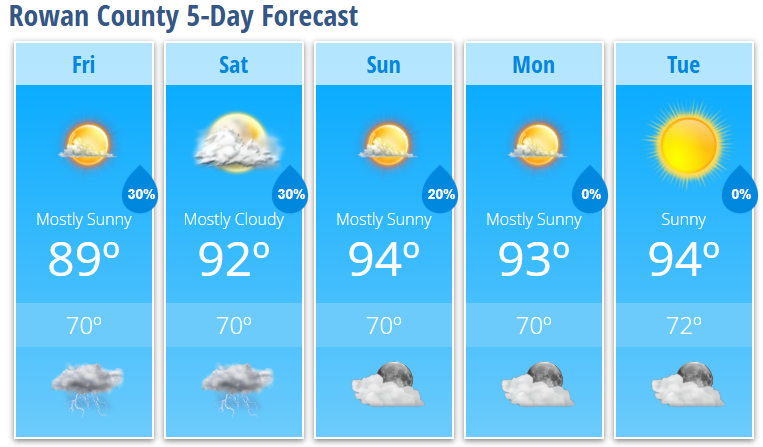
Friday: Mostly sunny. High 89°. 20% chance of afternoon thunderstorms.
Friday Night: Partly cloudy. Low 70°. 30% chance of evening storms.
Saturday: Mostly cloudy early, then becoming mostly sunny. High 92°. 30% chance of afternoon thunderstorms.
Saturday Night: Partly cloudy. Low 70°. 30% chance of evening storms.
Sunday: Mostly sunny. High 94°. 20% chance of afternoon thunderstorms.
Sunday Night: Mostly clear. Low 70°. 20% chance of early evening storms.
Monday: Mostly sunny. High 93°.
Monday Night: Mostly clear. Low 70°.
Tuesday: Sunny. High 94°.
Tuesday Night: Mostly clear. Low 72°.