Davie County Forecast: Hot Weekend Ahead, Isolated Strong Storms Possible Saturday
Summer heat continues building across Davie County as we head into the weekend. Afternoon temperatures will climb into the lower and middle 90s while humidity steadily increases, making it feel even hotter during the afternoon.
Scattered thunderstorms return beginning Friday night, with the greatest coverage expected Saturday afternoon and evening. While many communities will stay dry, a few storms Saturday could become strong with gusty winds before hotter and drier weather settles in during the first half of next week.
Forecast at a Glance
Friday
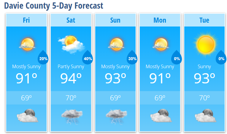
Mostly sunny with a high near 91°. Light south-southwest winds develop during the afternoon.
Friday Night
A 20% chance of evening showers and thunderstorms. Partly cloudy with a low around 69°.
Saturday
Partly sunny with a high near 94°. A 40% chance of afternoon and evening thunderstorms.
Saturday Night
Partly cloudy with a 30% chance of evening thunderstorms. Low around 70°.
Sunday
Mostly sunny with a high near 93°. A 30% chance of a late afternoon thunderstorm.
Sunday Night
Partly cloudy with a slight chance of an early evening thunderstorm. Low around 69°.
Monday
Mostly sunny with a high near 91°.
Monday Night
Mostly clear with a low around 69°.
Tuesday
Sunny and hot with a high near 93°.
Tuesday Night
Mostly clear with a low around 70°.
What I'm Watching
Moisture gradually increases across the region heading into the weekend, bringing back the chance for afternoon and evening thunderstorms.
Saturday continues to stand out as the day with the highest chance for storms. Daytime heating combined with increasing moisture and a weak disturbance moving through the region could allow a few storms to become strong enough to produce damaging wind gusts. While widespread severe weather is not expected, it's worth keeping an eye on the forecast if you have outdoor plans Saturday afternoon or evening.
By Sunday, thunderstorm coverage should become a bit more isolated as high pressure begins strengthening across the Southeast.
The bigger story next week will be the heat.
A strengthening upper-level ridge will continue building across the eastern United States, allowing temperatures to climb steadily through the week. Forecast guidance continues to suggest some Piedmont communities could approach 100° by the middle to latter part of next week, while heat index values climb into the triple digits. Heat Advisory conditions may become possible if current trends continue.
My Bottom Line
Prepare for a hot weekend with afternoon highs in the lower to middle 90s and scattered thunderstorms developing each afternoon. Saturday carries the greatest chance for storms, and a few could become strong with gusty winds.
Looking ahead, my attention continues to shift toward the increasingly hot weather expected next week. I'll continue monitoring both the thunderstorm potential and the growing heat and keep you updated as confidence increases.