Rowan County Forecast: Weekend Heat Builds, Isolated Strong Storms Possible Saturday
Summer heat continues to build across Rowan County as we head into the weekend. Afternoon temperatures will climb into the middle 90s, and when combined with increasing humidity, it will feel closer to 100 degrees during the hottest part of the day.
Scattered afternoon and evening thunderstorms return Friday and continue through the weekend. While not everyone will see rain, a few storms on Saturday could become strong to severe with gusty winds before hotter and drier weather develops next week.
Forecast at a Glance
Friday
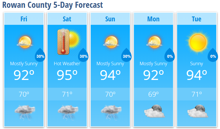
Mostly sunny with a 30% chance of afternoon and evening showers and thunderstorms after 4 PM. High near 92°.
Friday Night
Partly cloudy with a low around 70°.
Saturday
Partly sunny, hot, and humid with a high near 95°. Heat index values may reach 100°. A 30% chance of afternoon and evening thunderstorms, with a few storms possibly becoming strong.
Saturday Night
Partly cloudy with a lingering 30% chance of an evening thunderstorm. Low around 71°.
Sunday
Mostly sunny with a high near 94°. A 30% chance of a late afternoon thunderstorm.
Sunday Night
Partly cloudy with a slight chance of an early evening thunderstorm. Low around 70°.
Monday
Mostly sunny with a high near 92°.
Monday Night
Mostly clear with a low around 69°.
Tuesday
Sunny and hot with a high near 94°.
Tuesday Night
Mostly clear with a low around 71°.
What I'm Watching
The overall weather pattern is transitioning toward a hotter, more typical late June setup.
Beginning Friday, moisture returning from the south will allow scattered afternoon and evening thunderstorms to develop. Coverage increases slightly on Saturday as a weak upper-level disturbance and surface boundary move through the region. While widespread severe weather is not expected, the combination of hot temperatures, increasing humidity, and daytime heating could allow a few storms to produce damaging wind gusts, especially Saturday afternoon and evening.
By Sunday, thunderstorm coverage should become a bit more limited as strengthening high pressure begins building over the Southeast.
The bigger story heading into next week will be the heat.
A strengthening upper-level ridge will continue expanding across the eastern United States, allowing temperatures to climb even higher during the middle of next week. Some locations across the Piedmont could approach 100°, while heat index values are expected to climb well into the triple digits. If current trends continue, portions of the region could meet Heat Advisory criteria by late next week.
My Bottom Line
Plan on a hot weekend with afternoon highs in the 90s and heat index values around 100 degrees. Keep an eye on the sky each afternoon, especially Saturday, when a few thunderstorms could become strong with gusty winds.
Looking beyond the weekend, my attention is shifting toward what could become the hottest stretch of weather so far this year. I'll continue refining the forecast over the next several days and keep you updated on both the heat and any changes to the thunderstorm forecast.