Davidson County Forecast: Heat Builds Through the Weekend with Storm Chances Returning
A prolonged stretch of hot summer weather is setting up across Davidson County as temperatures climb into the 90s through the weekend and into early next week. While scattered afternoon thunderstorms return beginning Friday, the primary weather story will be the increasing heat.
Hotter Weather Returns
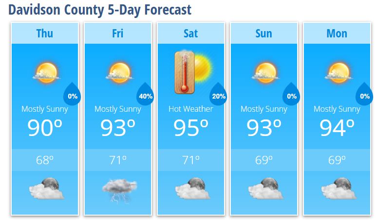
Thursday will be mostly sunny with a high near 90 degrees as high pressure continues to dominate the weather pattern.
By Friday, temperatures climb into the lower 90s with highs around 93 degrees. A 30 percent chance of showers and thunderstorms develops after 2 PM as moisture begins returning to the Carolinas. Most of the day will remain dry, but a few storms could develop during the afternoon and evening.
Weekend Heat Continues
Saturday will be one of the hottest days of the forecast period with mostly sunny skies and a high near 95 degrees. Only a slight chance of an afternoon thunderstorm is expected.
Sunday remains hot with highs around 93 degrees under mostly sunny skies. While most locations should stay dry, isolated afternoon thunderstorms remain possible as a weak backdoor cold front approaches the region.
Although humidity levels won't be excessively high, they'll be sufficient to push afternoon heat index values close to 100 degrees in parts of Davidson County. Areas farther east across central North Carolina could approach 105 degrees, and I'll continue monitoring forecast trends for any heat-related advisories.
Storm Chances Increase
Beginning Friday, a more typical summertime weather pattern returns with isolated to scattered afternoon and evening thunderstorms.
Rain coverage is expected to remain limited Friday and Saturday, with the better opportunity for scattered storms arriving Sunday as the backdoor cold front moves south through the Carolinas.
While widespread severe weather is not expected, any stronger storm could produce gusty winds and brief heavy rainfall.
Looking Ahead
Monday remains hot with highs in the mid-90s under mostly sunny skies. Behind the weak front, temperatures may ease slightly for a short time before forecast guidance suggests another potentially dangerous round of heat could develop during the middle to latter part of next week.
Heat Safety Tips
If you'll be spending time outdoors over the next several days:
- Drink plenty of water throughout the day.
- Wear lightweight, light-colored clothing.
- Take frequent breaks in the shade or air conditioning.
- Limit strenuous outdoor activities during the afternoon.
- Never leave children or pets inside a parked vehicle.
Davidson County Forecast
Thursday: Mostly sunny, high 90.
Thursday Night: Mostly clear, low 68.
Friday: Mostly sunny with a 30% chance of afternoon thunderstorms, high 93.
Friday Night: 40% chance of showers and thunderstorms, low 71.
Saturday: Mostly sunny with a slight chance of afternoon thunderstorms, high 95.
Saturday Night: Partly cloudy, low 71.
Sunday: Mostly sunny, high 93.
Sunday Night: Partly cloudy, low 69.
Monday: Mostly sunny, high 94.
Monday Night: Mostly clear, low 69..
The bottom line: Summer heat is settling in across Davidson County. Afternoon temperatures in the 90s, combined with increasing humidity, will make it feel much hotter through the weekend. Isolated thunderstorms return beginning Friday, but many communities will remain dry while the heat continues to build