Davidson County Weather Forecast: Strong Storms Possible This Evening, Cooler Air Arrives Midweek
Good Monday morning, Davidson County.
Today will be the hottest day of the week and will also bring our greatest chance for showers and thunderstorms as a cold front approaches from the northwest.
Some storms could become strong to severe later this afternoon and evening, with damaging wind gusts the primary concern.
What Has Changed
The severe weather forecast remains largely unchanged today. I am also watching a low-confidence possibility of a few stronger storms on Tuesday as the cold front exits the area.
Monday: Hot and Stormy
Temperatures will climb into the mid-90s this afternoon with humidity levels pushing heat index values close to 100 degrees.
Clouds will gradually increase through the day before scattered showers and thunderstorms develop late this afternoon and continue into the evening.
Today's Forecast
-
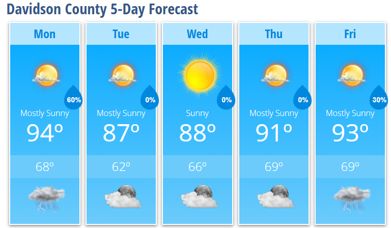
High: 94°
-
Heat Index: Near 100°
-
Southwest wind 5-10 mph
-
Wind gusts up to 20 mph
-
60% chance of showers and thunderstorms
The greatest threat for storms appears to be between 4 PM and 10 PM.
Severe Weather Threat
Davidson County remains within a Slight Risk for severe weather today.
The primary threats include:
-
Damaging straight-line winds
-
Frequent lightning
-
Heavy rainfall
-
Isolated hail
Atmospheric conditions support storms organizing into clusters as they move east out of the mountains. If that occurs, localized wind damage would become the main concern.
Most locations will receive between one-quarter and one-half inch of rainfall, but isolated areas could see 1 to 2 inches where stronger thunderstorms repeatedly move over the same location.
Tonight
Showers and thunderstorms will gradually diminish through the evening before ending overnight as the cold front approaches.
Tonight's Forecast
-
Low: 68°
-
60% chance of showers and thunderstorms before 11 PM
-
Becoming partly cloudy overnight
Tuesday Through Thursday: Lower Humidity Returns
A refreshing change arrives behind the cold front as humidity levels drop significantly.
Tuesday
-
Mostly sunny
-
High: 87°
-
Slight chance of an isolated shower
Tuesday Night
-
Clear
-
Low: 62°
Wednesday
-
Sunny
-
High: 88°
Thursday
-
Mostly sunny
-
High: 91°
The middle of the week will feature comfortable mornings, lower humidity, and plenty of sunshine.
Looking Ahead
Moisture begins returning late this week.
Friday
-
High: 93°
-
40% chance of afternoon and evening thunderstorms
Long-range guidance continues to suggest another period of significant summer heat developing next weekend and into early next week. High temperatures are expected to climb back into the 90s, with heat index values potentially exceeding 100 degrees once again.
For now, my focus remains on this afternoon and evening's severe weather potential. I'll be monitoring radar trends closely and will provide updates throughout the day if stronger storms begin developing west of Davidson County.