Rowan County Weather Forecast: Strong Storms Possible This Evening, Cooler Air Arrives Tuesday
Good Monday morning, everyone. Today will be the hottest day of the week, and it will also bring our best chance for strong to severe thunderstorms.
What Has Changed
The forecast remains largely on track. The severe weather threat today is unchanged, although I am also watching for a low-end possibility of a few stronger storms developing Tuesday as a cold front pushes through the region.
Monday: Heat and Storms
Temperatures will climb into the mid-90s this afternoon with increasing humidity. Heat index values could reach 100° to 104° in parts of central North Carolina, although Rowan County should generally remain near the lower end of that range.
Clouds will increase through the day, and scattered thunderstorms are expected to develop to our west and move into the area during the late afternoon and evening hours.
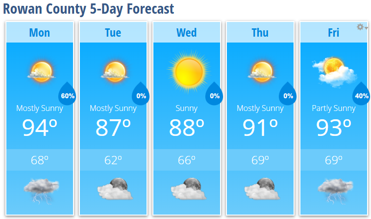
Today's Forecast
-
High: 94°
-
Southwest wind 5-10 mph with gusts up to 20 mph
-
60% chance of showers and thunderstorms after 5 PM
The Storm Prediction Center continues to place Rowan County in a Slight Risk for severe weather today.
Severe Weather Threat
The primary concern with any storms that develop will be:
-
Damaging straight-line winds
-
Frequent lightning
-
Heavy downpours
-
Isolated hail
Atmospheric conditions suggest some storms could organize into clusters as they move east out of the mountains. If that occurs, localized wind damage would become the main threat.
Not everyone will see a storm, but those who do could experience brief periods of strong winds and torrential rainfall.
Most locations will receive between one-quarter and one-half inch of rain, but isolated amounts of 1 to 2 inches are possible under stronger thunderstorms.
Tonight
Storm chances will continue through the evening before gradually diminishing later tonight as a cold front approaches from the northwest.
Tonight's Forecast
-
Low: 68°
-
60% chance of showers and thunderstorms, mainly before 11 PM
-
Becoming partly cloudy overnight
Tuesday Through Thursday: Much More Comfortable
Behind the cold front, noticeably lower humidity will move into the region.
Tuesday
-
Mostly sunny
-
High: 87°
-
Low: 62°
Wednesday
-
Sunny
-
High: 88°
-
Low: 66°
Thursday
-
Mostly sunny
-
High: 91°
-
Low: 69°
The lower humidity will make the middle part of the week feel much more comfortable despite temperatures remaining near seasonal levels.
Looking Ahead
The dry stretch continues through Thursday before moisture begins to return late in the week.
Friday
-
High: 93°
-
40% chance of afternoon and evening thunderstorms
Looking beyond this forecast period, long-range guidance continues to indicate another significant heat buildup across the Southeast next weekend and into early next week. I'll be watching that closely as temperatures may once again push well into the 90s with increasing humidity.
For now, keep an eye on the sky this afternoon and evening, especially if you have outdoor plans. I'll be monitoring radar trends throughout the day and will provide updates if stronger storms begin developing west of Rowan County.