Rowan County Weather Forecast
Strong Storms Possible Monday Evening Before a Brief Midweek Break
Good Sunday evening everyone!
The weather remains quiet tonight, but my attention continues to focus on Monday afternoon and evening as a cold front approaches the Carolinas. Strong to severe thunderstorms remain possible, with damaging winds continuing to be the primary concern.
Monday: Hot, Breezy, Then Stormy
Monday starts off dry with plenty of sunshine and temperatures quickly climbing through the 80s.
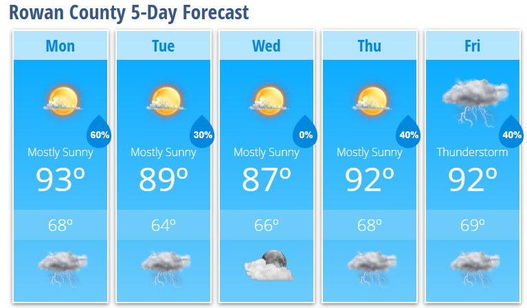
By afternoon, highs will reach around 93 degrees with southwest winds increasing to 6 to 13 mph and gusts as high as 22 mph.
While most of the day remains dry, a few isolated thunderstorms could develop after 3 PM. The greater concern continues to be a line of thunderstorms expected to develop ahead of an approaching cold front and move into the area during the late afternoon and evening.
The latest high-resolution guidance continues to show an environment supportive of strong to severe storms, with sufficient instability and wind shear in place.
Severe Weather Threat
The primary threat remains:
Damaging wind gusts
Additional hazards include:
Frequent lightning
Brief heavy rainfall
Downed tree limbs
Isolated power outages
Current guidance suggests the main severe weather window will be approximately 4 PM through Midnight, although the highest threat for Rowan County appears to be during the evening hours.
Some storms may develop ahead of the main line Monday afternoon, which could bring an earlier start to the threat for portions of the county.
Monday Night
Showers and thunderstorms remain likely Monday evening before gradually ending overnight as the cold front pushes east.
Skies will slowly clear after midnight with temperatures dropping to around 68 degrees.
Tuesday: Not Completely Done Yet
Tuesday won't be a washout, but I can't completely rule out a few additional showers or thunderstorms during the afternoon.
Widespread dense fog may greet some areas early Tuesday morning, especially where rain falls Monday evening.
Otherwise, expect mostly sunny skies with highs near 89 degrees.
A 30% chance of thunderstorms remains in the forecast after 3 PM.
Tuesday night brings a slight chance of an early evening storm before skies become partly cloudy with lows around 64 degrees.
Midweek Outlook
Wednesday looks like the nicest day of the forecast period.
Mostly sunny
High near 87°
Low near 66°
Humidity levels will also be a bit more comfortable compared to the start of the week.
Late Week Pattern
Summer weather returns for the second half of the week.
Thursday brings a 30% chance of afternoon thunderstorms with highs reaching 92 degrees.
Storm chances increase slightly Thursday night.
Friday features another chance of scattered showers and thunderstorms with highs again reaching the lower 90s.
My Take
Monday continues to be the day I'm watching most closely.
Confidence remains fairly high that thunderstorms will develop somewhere across the western Carolinas and move east during the afternoon and evening. The biggest question remains how much of that activity maintains its strength as it moves into the Piedmont.
While confidence in widespread severe weather is not especially high, confidence is increasing that at least some storms could produce damaging wind gusts.
If you have outdoor plans Monday afternoon or evening, make sure you have a way to receive weather warnings and be prepared to move indoors quickly if storms approach.
Rowan County Forecast
Monday: 20% chance of thunderstorms after 3 PM, high 93°
Monday Night: Showers and thunderstorms likely, low 68°
Tuesday: 30% chance of afternoon thunderstorms, high 89°
Tuesday Night: 30% chance of storms before 8 PM, low 64°
Wednesday: Mostly sunny, high 87°
Wednesday Night: Mostly clear, low 66°
Thursday: 30% chance of afternoon thunderstorms, high 92°
Thursday Night: 40% chance of thunderstorms, low 68°
Friday: 40% chance of showers and thunderstorms, high 92°
Friday Night: 30% chance of thunderstorms, low 69°