
Monday Severe Weather Threat Increasing: What Rowan, Davie, and Davidson Counties Need to Know
As we head into Monday, confidence continues to increase that portions of the western Carolinas and central North Carolina could see strong to severe thunderstorms during the afternoon and evening hours.
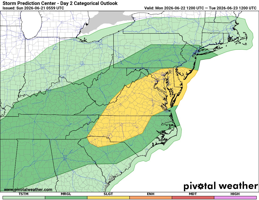
The Storm Prediction Center has expanded its Slight Risk (Level 2 of 5) severe weather outlook across much of central North Carolina, while Rowan, Davie, and Davidson counties remain within the broader area where strong storms are possible.
While not everyone will see severe weather, the ingredients are coming together for at least some storms to produce damaging wind gusts Monday evening.
What's Causing The Increased Concern?
A cold front currently moving across the Midwest and Ohio Valley will approach North Carolina Monday afternoon and evening.
Ahead of that front, temperatures are expected to climb into the middle 90s across much of the region, while humidity levels continue to increase. That combination will create an unstable atmosphere capable of supporting thunderstorms.
Forecast models continue to show:
✔ Increasing instability
✔ Sufficient wind shear for organized storms
✔ A line of thunderstorms developing west of the mountains and moving east during the evening
When those ingredients come together, confidence grows that at least some storms could become severe.
Primary Threat: Damaging Winds
At this time, damaging straight-line winds appear to be the greatest concern.
Strong thunderstorms will be capable of producing wind gusts exceeding 50 mph, which could:
Bring down tree limbs
Cause isolated power outages
Blow around unsecured outdoor objects
Create hazardous travel conditions
Frequent lightning and brief heavy downpours will also accompany stronger storms.
While a tornado cannot be completely ruled out this far in advance, damaging winds remain the primary concern based on current forecast guidance.
Expected Timing
Based on the latest forecast data, most of Monday will remain dry across Rowan, Davie, and Davidson counties.
Current timing suggests:
Morning through mid-afternoon: Dry and hot
Late afternoon: Isolated storms possible
Main storm window: Approximately 6 PM through Midnight
Overnight: Storms gradually weaken and move east
As always, timing can shift by a few hours and I'll continue refining the forecast as newer data becomes available.
Why Confidence Is Increasing
Over the past 24 hours, forecast models have become more consistent regarding:
• The arrival of the cold front
• Development of thunderstorms west of the mountains
• Eastward movement of storms into the Piedmont Monday evening
• The potential for storms to organize into a stronger line capable of producing damaging winds
When multiple forecast models begin showing similar solutions, confidence naturally increases in the forecast.
That doesn't guarantee severe weather will occur in every community, but it does increase confidence that at least some areas across the region could experience stronger storms.
What I'll Be Watching
Between now and Monday evening, several factors will determine how significant the threat becomes:
Whether instability continues to increase in forecast guidance
The exact timing of the cold front
The strength and organization of storms developing over the mountains
Any future adjustments to the Storm Prediction Center outlook
If confidence continues to increase, additional outlooks or risk area expansions could occur before Monday afternoon.
My Bottom Line
Today looks fantastic with sunshine and seasonably warm temperatures.
Monday is the day to watch.
At this point, I expect most locations across Rowan, Davie, and Davidson counties to remain dry through much of the day before thunderstorms develop during the evening hours.
Not everyone will experience severe weather, but confidence is increasing that some storms could produce damaging wind gusts as they move through the area.
I'll continue monitoring forecast trends and will provide updates throughout the day Sunday and again Monday as we get closer to the event.
Stay weather aware, and make sure you have multiple ways to receive warnings Monday evening.