Davie County Weather Forecast
Hot and Mostly Dry Today, Strong Storms Possible Monday Evening
Good Sunday morning, Davie County!
Summer is off to a hot start across the area, with plenty of sunshine expected today before thunderstorm chances increase Monday as a cold front approaches from the northwest.
Today: Sunshine and Summer Heat
Expect a beautiful first full day of summer with sunny skies and temperatures reaching around 92 degrees this afternoon. Winds will remain light and variable throughout the day.
Tonight will be mostly clear and warm with temperatures falling to around 69 degrees.
Monday: Heat, Humidity, Then Storms
Monday will be another hot day with highs reaching 94 degrees under mostly sunny skies.
While much of the day will be dry, I'll be closely monitoring the potential for strong to severe thunderstorms during the late afternoon and evening hours.
A cold front approaching from the northwest will provide the focus for storm development. Forecast models continue to indicate enough instability and wind shear to support strong storms capable of producing damaging wind gusts.
A few isolated storms could develop during the afternoon, but the greatest threat appears to be Monday evening as a more organized line of storms approaches from the west.
Southwest winds will increase during the day with occasional gusts up to 20 mph ahead of the front.
If you have outdoor activities planned Monday evening, make sure you have a reliable way to receive weather alerts and be prepared to move indoors quickly if storms approach.
Monday night brings an 80% chance of showers and thunderstorms, mainly before midnight, with temperatures falling to around 68 degrees.
Tuesday Through Wednesday: Slightly Cooler
Tuesday will feature a mix of sunshine and a small chance of an afternoon thunderstorm as the front moves east of the area. High temperatures will reach around 89 degrees.
Tuesday night will be partly cloudy with lows around 63 degrees.
Wednesday looks very pleasant for late June with mostly sunny skies and highs near 88 degrees. Overnight lows Wednesday night will settle around 66 degrees.
Looking Ahead
A typical summertime weather pattern returns Thursday with scattered afternoon and evening thunderstorms possible.
Thursday's high will be near 90 degrees with a 40% chance of thunderstorms developing after 2 PM.
Storm chances continue Thursday night before gradually decreasing overnight.
My Take
Today is the pick of the forecast with sunshine, low rain chances, and typical summer warmth.
Monday is the day to watch. Confidence continues to increase that strong thunderstorms could impact Davie County Monday evening. Damaging wind gusts remain the primary concern, and I'll be monitoring forecast trends closely over the next 24 hours.
Davie County Forecast
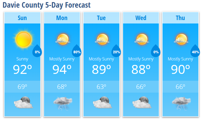
Sunday: Sunny, high 92°
Sunday Night: Mostly clear, low 69°
Monday: 30% chance of afternoon thunderstorms, high 94°
Monday Night: Showers and thunderstorms likely, low 68°
Tuesday: Slight chance of afternoon thunderstorms, high 89°
Tuesday Night: Partly cloudy, low 63°
Wednesday: Mostly sunny, high 88°
Wednesday Night: Mostly clear, low 66°
Thursday: 40% chance of afternoon thunderstorms, high 90°
Thursday Night: 40% chance of thunderstorms, low 66°