
Strong Thunderstorm Moving Toward Western Rowan County
The National Weather Service is tracking a strong thunderstorm moving through eastern Iredell County and toward portions of western Rowan County this afternoon.
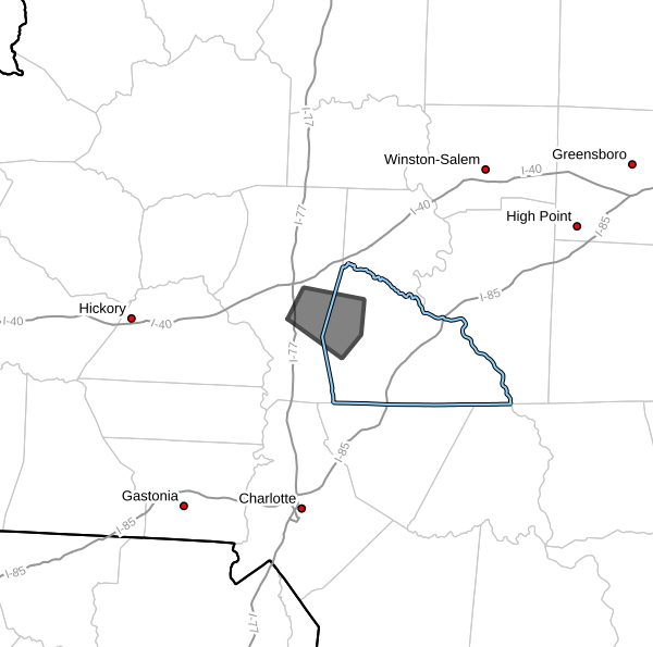
At 4:58 PM EDT, Doppler radar indicated a strong thunderstorm located about 7 miles southeast of Statesville, or approximately 5 miles west of Cleveland, moving east at 15 mph.
Areas That Could Be Impacted
The storm is expected to affect portions of:
- Cleveland
- Mount Ulla
- Western Rowan County
- Eastern Iredell County
- Areas near Statesville
Main Threats
According to the National Weather Service, this storm is capable of producing:
Wind gusts between 50 and 55 mph
Nickel-size hail
While widespread severe weather is not expected, winds of this magnitude can break small tree limbs and blow around unsecured outdoor objects.
Minor damage to vehicles, outdoor furniture, and other exposed objects is also possible from hail.
What To Expect
Residents in western Rowan County may notice:
- Increasing clouds
- Brief heavy rainfall
- Frequent lightning
- Gusty winds
- Small hail
The storm is moving east at approximately 15 mph and could reach portions of western Rowan County during the next several minutes.
Safety Reminder
If you are outdoors, consider moving inside a sturdy building until the storm passes.
Remember, lightning can strike several miles away from the heaviest rain and strongest winds.
Rowan County Weather will continue monitoring the storm and provide additional updates if warnings become necessary.