
Strong Thunderstorms Impacting Portions of Rowan, Davie, Iredell, Alexander, and Catawba Counties
A line of strong thunderstorms continues to move across portions of the western Piedmont this evening, prompting a Special Weather Statement from the National Weather Service.
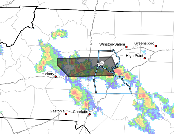
As of 5:27 PM, Doppler radar indicated strong thunderstorms extending from north of Salisbury to northeast of Newton. The line of storms was moving northwest at approximately 10 mph.
Hazards Associated With These Storms
The National Weather Service reports these storms are capable of producing:
- Wind gusts up to 40 mph
- Pea to dime-sized hail
- Frequent lightning
- Heavy rainfall
While the storms are currently below severe thunderstorm warning criteria, they remain capable of producing hazardous weather conditions.
Areas Impacted
Communities that may be affected include:
- Statesville
- Mocksville
- Taylorsville
- Stony Point
- Cooleemee
- Harmony
- Cleveland
- Claremont
- Bethlehem
- Lookout Shoals Lake
Residents across northwestern Rowan County, central Davie County, central Iredell County, Alexander County, and portions of Catawba County should remain weather aware as the storms continue moving through the region.
Wind, Hail, and Lightning Threat
Wind gusts approaching 40 mph may be strong enough to knock down small tree limbs and blow around unsecured outdoor objects. Small hail is also possible and may cause minor damage to vehicles, outdoor furniture, and other exposed items.
Frequent lightning will accompany these storms and can strike well away from the heaviest rainfall. Anyone hearing thunder should move indoors immediately.
Additional Development Possible
The atmosphere remains unstable this evening, and additional thunderstorms may continue to develop across the region.
While widespread severe weather is not expected, stronger cells could still produce localized impacts including gusty winds, brief hail, and heavy rainfall.
Stay Weather Aware
Residents in the affected areas should continue monitoring weather conditions and be prepared to seek shelter if storms approach.
Rowan County Weather will continue tracking radar trends and will provide updates if additional statements, advisories, or warnings are issued by the National Weather Service.