
Strong Thunderstorm Moving Through Portions of Davie, Rowan, and Iredell Counties
A strong thunderstorm continues to move through portions of the western Piedmont this afternoon, prompting a Special Weather Statement from the National Weather Service.
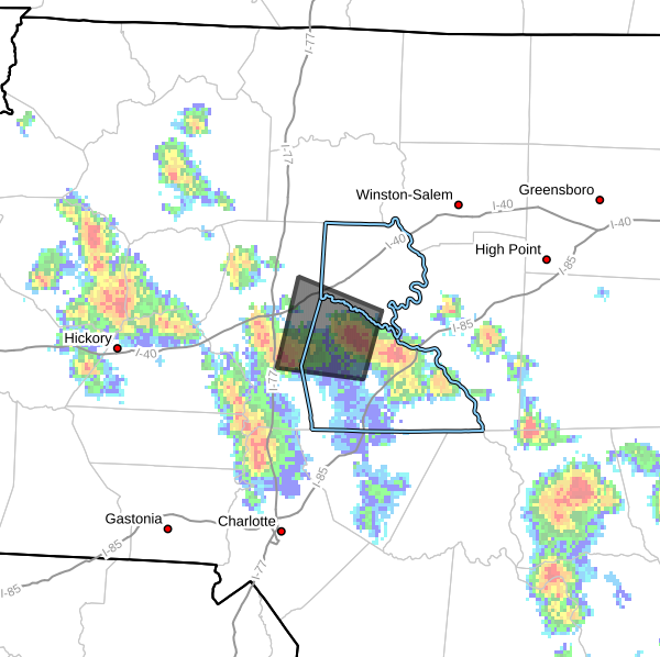
As of 4:52 PM, Doppler radar indicated a strong thunderstorm located near Cleveland, approximately 9 miles northwest of Salisbury. The storm was moving west at around 10 mph.
Hazards Associated With This Storm
The National Weather Service reports the storm is capable of producing:
- Wind gusts up to 40 mph
- Pea-sized hail
- Frequent lightning
- Torrential rainfall
While the storm is not currently severe warned, it remains capable of producing locally hazardous weather conditions.
Areas Impacted
Communities that may be affected include:
- Cleveland
- Mount Ulla
- Woodleaf
- Cooleemee
- East Statesville
- Cool Springs
- Piedmont Research Station
Residents in northwestern Rowan County, southwestern Davie County, and eastern Iredell County should remain alert as the storm moves through the area.
Heavy Rainfall May Cause Localized Flooding
The storm is producing periods of torrential rainfall that may lead to localized flooding, especially in low-lying and poor drainage areas.
Motorists should exercise caution and never attempt to drive through flooded roadways. Even a small amount of moving water can create dangerous driving conditions.
Wind and Hail Threat
Wind gusts approaching 40 mph may be strong enough to knock down small tree limbs and blow around unsecured outdoor objects. Small hail is also possible and could cause minor damage to vehicles, patio furniture, and other outdoor items.
Stay Weather Aware
Anyone outdoors in the affected area should consider moving indoors until the storm passes. Frequent lightning can occur well away from the heaviest rainfall.
Additional showers and thunderstorms remain possible through the evening across Rowan, Davie, and surrounding counties as an unsettled weather pattern continues.
Rowan County Weather will continue monitoring conditions and provide updates if additional statements or warnings are issued.