
Strong Thunderstorms Impacting Portions of Iredell and Rowan Counties
Strong thunderstorms continue to move across portions of the western Piedmont this afternoon, prompting a Special Weather Statement from the National Weather Service.
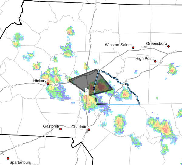
As of 4:22 PM, Doppler radar indicated a line of strong thunderstorms extending from just west of Salisbury to southeast of Statesville. The storms were moving northwest at approximately 10 mph.
Primary Hazards
The strongest storms may produce:
- Wind gusts up to 50 mph
- Pea-sized hail
- Frequent lightning
- Torrential rainfall
While these storms are not currently severe warned, they are capable of producing locally hazardous weather conditions.
Areas Impacted
Communities that may be impacted include:
- Statesville
- Troutman
- Cleveland
- Mount Ulla
- Mooresville
- Cool Springs
- Lake Norman State Park
- Piedmont Research Station
Residents in northwestern Rowan County and central Iredell County should remain weather aware as these storms continue to move through the area.
Heavy Rainfall and Localized Flooding Possible
In addition to gusty winds and small hail, these storms are producing periods of heavy rainfall.
Localized flooding may occur in low-lying and poor drainage areas. Motorists are urged to use caution and never drive through flooded roadways.
Severe Weather Threat Remains Limited
While widespread severe weather is not expected today, the atmosphere remains unstable enough to support stronger thunderstorms capable of producing isolated damaging wind gusts.
Additional shower and thunderstorm development remains possible through the evening hours across Rowan County and surrounding communities.
Stay Weather Aware
Anyone with outdoor activities planned this evening should continue monitoring weather conditions and have multiple ways to receive warnings if stronger storms develop.
Rowan County Weather will continue monitoring radar trends and provide updates if additional statements or warnings are issued.