
Strong Thunderstorm Moving Through Davie, Iredell & Northwestern Rowan Counties Until 5:15 PM
A strong thunderstorm continues moving across portions of Davie County, eastern Iredell County, and northwestern Rowan County this afternoon, bringing heavy rain, gusty winds, lightning, and the potential for small hail.
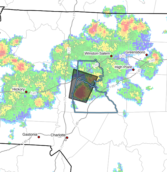
As of 4:25 PM, Doppler radar indicated a strong thunderstorm located near Cleveland, or about 11 miles west of Salisbury, moving north at around 10 mph.
Main Threats
- Wind gusts up to 40 mph
- Half-inch hail
- Torrential rainfall
- Frequent lightning
While this storm remains below severe thunderstorm warning criteria, it is capable of producing locally strong wind gusts that could knock down tree limbs and blow around unsecured outdoor objects. Minor hail damage to outdoor items is also possible.
Flooding Concerns
Very heavy rainfall is occurring with this storm and could lead to localized flooding, especially in low-lying and poor drainage areas.
Drivers are urged to use caution and never attempt to drive through flooded roadways.
Areas Impacted
Communities that could be impacted through 5:15 PM include:
- Mocksville
- Cooleemee
- Cleveland
- Fork Church
- Mount Ulla
- Piedmont Research Station
- Woodleaf
- Cool Springs
What To Expect
This storm is part of the scattered afternoon thunderstorm activity developing across the western Piedmont today. Storms remain hit-or-miss, but any stronger storm can quickly produce dangerous lightning, torrential rainfall, and brief gusty winds.
If you are outdoors, now is a good time to move inside a sturdy building until the storm passes.
Rowan County Weather will continue monitoring radar trends through the evening hours.