
Increased Fire Danger Wednesday Across Western North Carolina
Please take a moment to visit our local sponsors to let them know that you appreciate their support of our blog.
advertise your local business here »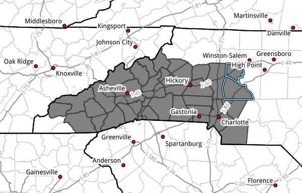
WHAT HAS CHANGED
- An Increased Fire Danger Statement has been issued for Wednesday across much of western North Carolina.
- Conditions will support a higher risk for the rapid spread of wildfires.
KEY MESSAGES
- Elevated fire danger develops Wednesday morning and lasts through the evening.
- Very dry air (20–30% humidity) and gusty winds (20–25 mph) will create favorable wildfire conditions.
- A statewide burn ban remains in effect—outdoor burning is not allowed.
AREAS INCLUDED
This includes a large portion of western and central North Carolina, including:
Avery, Alexander, Iredell, Davie, Madison, Yancey, Mitchell, Swain, Haywood, Buncombe, Catawba, Rowan, Graham, Jackson, Macon, Transylvania, Henderson, Cleveland, Lincoln, Gaston, Mecklenburg, Cabarrus, Union, Caldwell, Burke, McDowell, Rutherford, and Polk counties.
DISCUSSION
Conditions on Wednesday will become favorable for wildfire development and spread across western North Carolina.
Afternoon relative humidity values are expected to drop into the 20 to 30 percent range, while winds increase with gusts reaching 20 to 25 mph. When you combine these factors with very dry vegetation and ongoing drought conditions, it creates an environment where fires can start easily and spread quickly.
Even small sparks—whether from equipment, discarded cigarettes, or other sources—can quickly become dangerous under these conditions.
BURN BAN IN EFFECT
A statewide burn ban has been issued by the North Carolina Forest Service.
- All outdoor burning is prohibited
- This includes yard debris, fire pits, and open burning of any kind
Violations of the burn ban can result in fines and increased risk to property and life.
WHAT TO WATCH
- Wednesday afternoon will be the peak window for fire danger
- Breezy conditions will make any fire difficult to control
- Even though temperatures will be warm and skies mostly sunny, conditions will be dangerous for outdoor burning
FINAL TAKEAWAY
Wednesday may look like a perfect spring day, but the combination of dry air, gusty winds, and dry fuels makes it a high-risk day for wildfire spread.
Avoid any activity that could create sparks, and follow the statewide burn ban.
Please let our local sponsors know that you appreciate their support of our blog. Take a moment to visit their website linked at the top of this post.
Share this:

Announcements & Events
Check back often for important announcements and events that I'll be involved in!