Latest Update from the National Hurricane Center on Hurricane Melissa
During the last center fix of the Air Force Reserve mission into Melissa several hours ago, a dropsonde measured a surface pressure of 989 mb with winds of 27 kt, suggesting that the central pressure has fallen to about 986 mb. The aircraft did not measure stronger winds but did not sample the area due east of the center, where a nearly coincident ASCAT pass suggested the strongest winds would be located.
Some westerly shear is still present, but the center is now embedded under the Central Dense Overcast, with Dvorak estimates of T4.0/65 kt from TAFB and T3.5/55 kt from SAB. The current intensity is estimated at 60 kt (70 mph) based on these data. Radar images from Jamaica have also occasionally shown an eye feature.
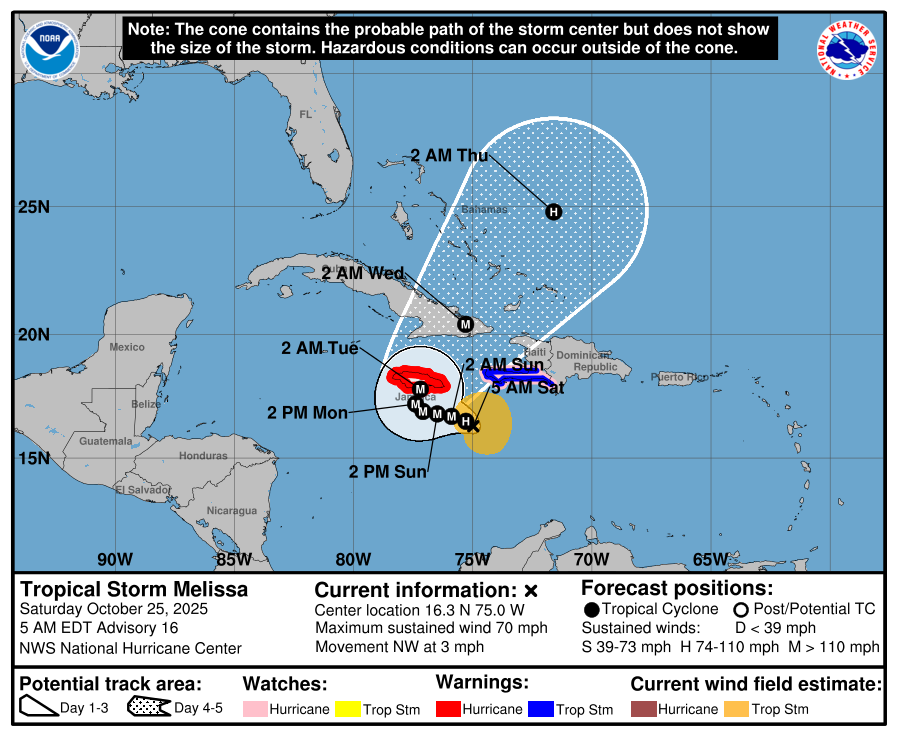
Melissa is currently moving slowly northwest at about 3 kt. Steering currents will remain weak through the weekend, with the storm expected to drift westward to the south of Jamaica through Sunday night. A gradual northward turn is expected Monday and Monday night. Most track models indicate Melissa will make landfall on Jamaica in about 72 hours, bringing several days of heavy rainfall and tropical-storm-force winds before the core reaches the island.
By days four and five, Melissa is forecast to accelerate northeast across eastern Cuba, the southeastern Bahamas, and the Turks and Caicos Islands. Model agreement is good on this general track.
Despite ongoing westerly shear, high oceanic heat content and strong upper-level divergence are expected to support rapid intensification. The NHC notes a very high probability of a 55-kt increase in intensity over the next 48 hours, with the storm potentially peaking at Category 4 or 5 strength (around 135 kt) by Monday afternoon. Some weakening may occur later due to land interaction or eyewall replacement, but Melissa could still make landfall in Jamaica as a major hurricane.
Key Messages:
-
Jamaica: Melissa’s slow movement will bring a multi-day period of damaging winds and heavy rainfall beginning tonight. Catastrophic flash flooding, landslides, and life-threatening storm surge are possible early next week.
-
Haiti: Catastrophic flash flooding and landslides are expected in southwestern Haiti, with prolonged isolation of communities possible.
-
Dominican Republic: Heavy rainfall could lead to catastrophic flash flooding and numerous landslides in southern regions.
-
Eastern Cuba, Bahamas, and the Turks and Caicos: Increasing risk of storm surge, damaging winds, and flash flooding by midweek.
Source: National Hurricane Center, 8:00 AM EDT Update