
Tropical Storm Imelda – 2 PM EDT Update (NHC)
Issued: Sunday, September 28, 2025 • 2:00 PM EDT
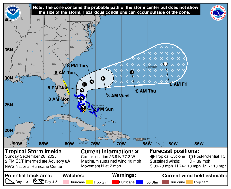
Source: NWS National Hurricane Center – Intermediate Advisory 8A
Overview
The depression has strengthened into Tropical Storm Imelda. While current guidance still shows a turn to the east-northeast away from the Southeast U.S. by midweek, that turn will take time, so near-term impacts continue along the Bahamas and portions of the U.S. East Coast.
Current Position & Intensity
-
Location: 23.9°N, 77.3°W (about 95 miles WNW of the central Bahamas; ~370 miles SE of Cape Canaveral, FL)
-
Movement: North at 7 mph
-
Maximum sustained winds: 40 mph (tropical-storm force)
-
Minimum central pressure: 998 mb
Watches & Warnings
-
Tropical Storm Warning: Central Bahamas (Cat Island, Exumas, Long Island, Rum Cay, San Salvador) and portions of the northwestern Bahamas (Eleuthera, New Providence, Abacos, Berry Islands, Andros, Grand Bahama).
-
Tropical Storm Watch: Florida east coast from the Palm Beach/Martin County Line to the Flagler/Volusia County Line.
Forecast & Track
-
Motion to the north continues today, becoming faster.
-
A turn to the east-northeast is expected Monday–Tuesday, taking the center away from the Southeast U.S. by midweek.
-
Strengthening is likely; Imelda could become a hurricane late Monday or Tuesday.
Hazards
-
Wind: Tropical-storm conditions occurring in the central Bahamas; expected in the northwestern Bahamas later today. Possible along the Florida east coast within the Watch area Monday.
-
Rainfall:
-
Eastern Cuba: Additional 2–6 inches; flash flooding and mudslides possible.
-
Northwestern Bahamas: 6–12 inches through Tuesday; flash/urban flooding likely.
-
Coastal Carolinas: 2–4 inches, locally up to 7 inches through Wednesday morning; flash/urban and isolated minor river flooding possible.
-
-
Storm Surge: 1–3 feet above ground level in onshore flow across the northwestern Bahamas. Minor coastal flooding possible along parts of the Southeastern U.S. coast.
-
Surf/Rip Currents: Swells from Imelda and Hurricane Humberto will bring dangerous surf and rip currents to much of the U.S. East Coast early this week.
Rowan County Outlook
-
Timing: Monday–Tuesday remain our most unsettled period.
-
What to expect: Breezy northeast winds, periods of showers, and pockets of heavier rain.
-
Key point: The forecast shows a sharp turn offshore, but not immediately—local impacts persist until the system accelerates east-northeast.
Residents with coastal plans should follow local beach flags and advisories. Continue to monitor updates for any adjustments to the track or rainfall outlook.
Please let our local sponsors know that you appreciate their support of our blog. Take a moment to visit their website linked at the top of this post.
Share this:

Announcements & Events
Check back often for important announcements and events that I'll be involved in!