
Tropical Weather Outlook – Tuesday Morning Update
Source: National Hurricane Center (2 AM EDT, Sept. 23, 2025)
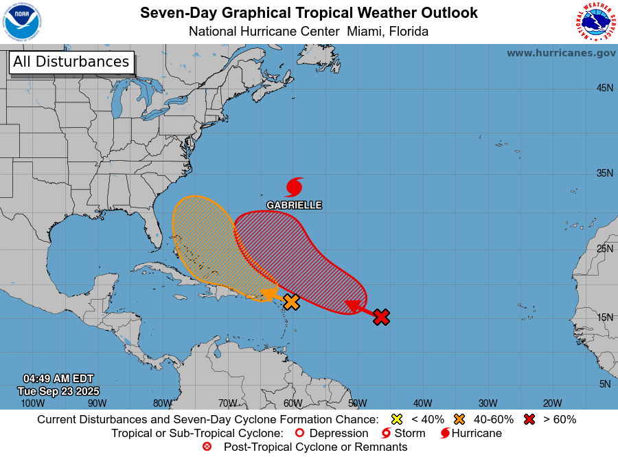
Active System
-
Hurricane Gabrielle remains a powerful hurricane over the central subtropical Atlantic.
-
Current intensity is estimated at 120 mph (Category 3), though gradual weakening is expected as it moves into cooler waters and higher wind shear.
-
Gabrielle is forecast to move northeast and eventually transition to a post-tropical system near the Azores later this week.
-
Impacts: Swells from Gabrielle will continue to generate life-threatening surf and rip current risks along the U.S. East Coast (from North Carolina northward), Bermuda, and Atlantic Canada over the next couple of days.
Central & Western Tropical Atlantic
-
A tropical wave about 1,000 miles east of the Lesser Antilles is showing better organization.
-
Environmental conditions are becoming more favorable, and a tropical depression is likely to form by Thursday or Friday as the system moves west-northwest to northwest.
-
Formation chances:
-
48 hours: 30% (low)
-
7 days: 80% (high)
-
East of the Leeward Islands
-
Another tropical wave is located just east of the Leeward Islands.
-
Currently producing disorganized showers and storms, but slow development is possible as it tracks west-northwest.
-
A tropical depression could form later this week when the disturbance nears the Bahamas or the southwestern Atlantic.
-
Regardless of development, gusty winds and heavy rainfall are expected in the Leeward Islands tonight into Tuesday, then in Puerto Rico and the Virgin Islands Tuesday into Wednesday.
-
Formation chances:
-
48 hours: 10% (low)
-
7 days: 50% (medium)
-
Key Messages on Hurricane Gabrielle
-
Swells from Gabrielle will continue to impact Bermuda, the U.S. East Coast north of the Carolinas, and Atlantic Canada. These swells will cause dangerous surf and rip currents.
-
Azores: Gabrielle is forecast to approach late Thursday. Residents there should monitor forecasts closely for potential wind, rain, and wave impacts later this week.
Please let our local sponsors know that you appreciate their support of our blog. Take a moment to visit their website linked at the top of this post.
Share this:

Announcements & Events
Check back often for important announcements and events that I'll be involved in!