
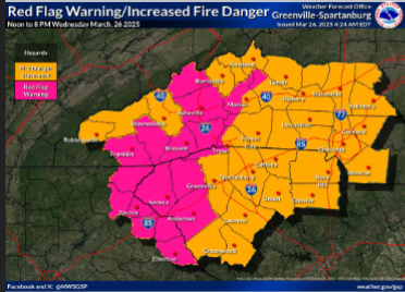
Red Flag Warning & Increased Fire Danger Today
Wednesday, March 26, 2025 - 8:52am
OVERVIEW
Very dry air remains across the area today, with west to northwest winds increasing and becoming gusty by afternoon. Any fires that develop will have the potential to spread rapidly.
TIMING ▪
Through this evening.
HAZARDS & IMPACTS
▪ Critical fire weather conditions will lead to extreme fire behavior.
▪ Sustained west to northwest winds of 10 to 20 mph, with gusts of 20 to 35 mph develop across the area by afternoon. Wind speeds diminish by late this evening.
▪ 10-hour fuel moisture already less than 10 percent across much of the area.
▪ Minimum relative humidity of 15 to 25 percent for all but the higher elevations where they fall to around 35 percent.
NWS ALERTS
▪ Red Flag Warning in effect from Noon through 8 PM.
▪ Special Weather Statement for Increased Fire Danger in effect from Noon to 8 PM for areas not in the Red Flag Warning.
ADDITIONAL INFORMATION
▪ A statewide burn ban remains in effect until further notice, prohibiting outdoor burning, per the South Carolina Forestry Commission.
▪ A statewide burn ban on all open burning remains in effect until further notice per the North Carolina Forest Service.
Please let our local sponsors know that you appreciate their support of our blog. Take a moment to visit their website linked at the top of this post.
Share this:

Announcements & Events
Check back often for important announcements and events that I'll be involved in!