
Weekend Coastal Storm Could Bring Rain Farther Inland Across North Carolina
Friday, November 20, 2026 | Rowan County Weather & Regional Forecast
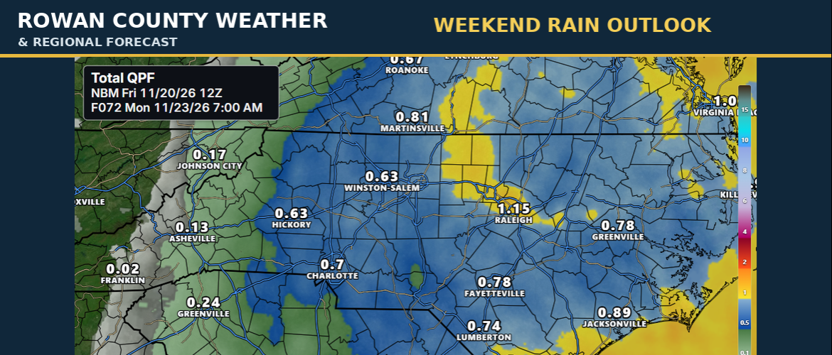
North Carolina is heading into a weekend that could bring very different weather conditions depending on where you live. A developing coastal storm is expected to bring rain to portions of the state Saturday night and Sunday, and the latest forecast guidance suggests that some of that rain could spread farther inland than previously anticipated.
The biggest question this morning isn't whether the storm will develop. It's how far west the rain will reach and how much will fall.
Saturday Still Looks Favorable for Most Inland Plans
For Rowan, Davie, Davidson, Cabarrus, and Iredell counties, much of Saturday should remain dry, although clouds will increase as the coastal system develops.
Afternoon temperatures should generally reach the lower to middle 60s. That should allow most daytime outdoor activities to proceed without significant weather problems.
Conditions could begin changing Saturday evening as moisture spreads inland from the coast.
Rain Chances Increasing Saturday Night and Sunday
The latest forecast has increased rain chances across portions of central North Carolina.
For our immediate coverage area, Saturday night into Sunday is the period to watch. Rain could develop overnight and continue at times Sunday, although the coverage and intensity will depend on the eventual storm track.
A track closer to the coastline would allow more moisture to spread westward into the Piedmont. A track farther offshore could keep the heaviest rain concentrated across eastern North Carolina.
This is why rainfall totals remain uncertain, even as confidence increases that the state will see a coastal storm.
Coastal North Carolina Could See Greater Impacts
The more significant weather impacts are expected closer to the coast.
The Cape Fear region could receive 1 to 2 inches of rain, based on Friday morning's forecast. Rainfall could become more widespread Saturday night, with periods of heavier rain possible.
Along the Outer Banks and central coast, increasing winds and rough marine conditions will also be concerns. Small Craft Advisories and a Gale Watch have been issued for portions of the coastal waters.
Anyone planning to travel toward Wilmington, the Crystal Coast, or the Outer Banks this weekend should monitor the forecast closely, particularly for Sunday.
What About the Mountains?
Western North Carolina is farther removed from the developing coastal low, so the risk of significant rainfall from this particular system appears lower.
That means the weekend weather could range from relatively quiet conditions in the mountains to periods of rain across the Piedmont and a wetter, windier pattern along the coast.
Another System Possible Near Thanksgiving
This weekend's storm may not be the last weather system to affect North Carolina before Thanksgiving.
Forecast guidance continues to indicate the potential for another low-pressure system around the middle of next week. Its timing, track, and impacts are not yet settled.
With Thanksgiving travel approaching, that will be another forecast worth following over the next several days.
What We're Watching Next
The most important forecast changes today will involve the western extent of the rain, expected rainfall totals, and how quickly conditions improve Sunday.
For our five-county regional coverage area, Saturday daytime remains the better opportunity for outdoor activities. Sunday carries the greater chance of rain.
We'll continue following the coastal system as newer forecast information becomes available throughout Friday.