
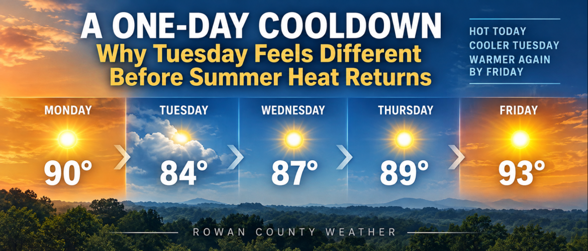
A One-Day Cooldown: Why Tuesday Feels Different Before Summer Heat Returns
After another hot September afternoon across the region Monday, a subtle change in the weather pattern will knock temperatures down Tuesday. But anyone hoping this marks the beginning of a sustained transition toward fall will have to wait a little longer.
A backdoor cold front moving south through the Carolinas Monday will bring a brief shot of more seasonable air to Rowan, Davie, Davidson and Cabarrus counties. Unlike many cold fronts that approach the Carolinas from the west or northwest, this boundary is dropping into the region from the north and northeast.
It will not bring much in the way of rain. Instead, the most noticeable change will be the temperature.
One More Hot Day Monday
Temperatures Monday will reach around 90 degrees across much of the region.
Rowan County is forecast to reach 89 degrees, while Davie and Davidson counties climb to around 90. Cabarrus County could reach 91.
Those temperatures are running above normal for the middle of September.
Despite the approaching front, the atmosphere does not have much moisture or instability available to produce showers and thunderstorms. An isolated shower cannot be completely ruled out in parts of the Carolinas, but most locations in the Rowan County Weather coverage area should remain rain-free.
The front will primarily make itself known through a shift in the wind and the cooler air that follows.
Tuesday Will Feel Different
Tuesday brings the most noticeable temperature change of the week.
Forecast highs include:
Rowan County: 84 degrees
Davie County: 85 degrees
Davidson County: 84 degrees
Cabarrus County: 85 degrees
That is a drop of roughly five to six degrees from Monday afternoon.
An easterly flow behind the front may also bring some additional cloud cover, particularly during the first part of Tuesday. Cabarrus County could begin the day mostly cloudy before gradually becoming sunny.
Despite the clouds, there is little support for precipitation.
Cooler Nights Return
The change will become even more noticeable Tuesday night into Wednesday morning.
Forecast lows fall to around 59 degrees in Rowan and Davidson counties, 60 in Davie County and 61 in Cabarrus County.
For anyone stepping outside early Wednesday morning, that will provide a much different feel compared with the recent stretch of warm and humid mornings.
Sunshine quickly takes over Wednesday, however, and temperatures begin their climb again.
The Cooldown Doesn't Last
Tuesday's change is not the beginning of a prolonged stretch of cooler weather.
A strong ridge of high pressure in the upper atmosphere will strengthen across the Tennessee Valley and southern Appalachians during the middle and latter portions of the week.
As that happens, temperatures rebound.
Wednesday's highs should reach the upper 80s, followed by upper 80s again Thursday.
Then comes Friday.
Current forecasts call for highs around 92 degrees in Davie County and 93 degrees in Rowan, Davidson and Cabarrus counties.
In other words, Tuesday's mid-80s will be a temporary interruption in what remains a very warm September pattern.
Rain Remains Hard to Find
The other notable part of this week's forecast is the lack of meaningful rainfall.
The front moving through Monday is expected to produce little, if any, precipitation across the immediate area. Behind it, high pressure will help suppress shower and thunderstorm development through much of the workweek.
There had been some indication that rain chances could begin increasing again later this week or during the weekend, but confidence in that scenario remains low.
Some forecast guidance suggests deeper moisture could eventually return northward from the Gulf region. Other guidance has been delaying the return of better rain chances until late in the weekend or even early next week.
That portion of the forecast will need to be watched over the coming days.
Summer Isn't Ready to Leave
September is a transition month in North Carolina, and this week will provide a good example.
We'll go from highs around 90 Monday to the mid-80s Tuesday, experience morning temperatures around 60 Wednesday, and then potentially climb right back into the lower 90s Friday.
The cooler air Tuesday and Wednesday morning may provide a welcome break from the heat, but don't pack away the summer clothes just yet.
Summer temperatures aren't finished with the Carolinas.