
Remnants of Dolly Continue West as Gulf System Bears Watching
The Atlantic tropics remain active this weekend, but neither of the two areas currently being monitored has a significant chance of tropical development.
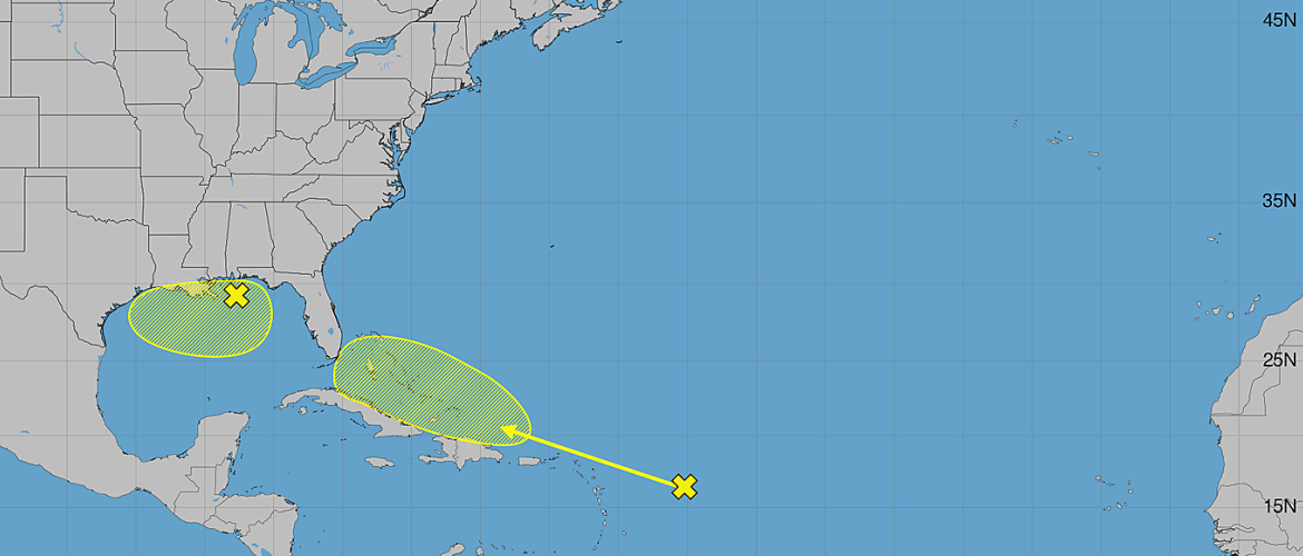
As of Saturday morning, August 29, the remnants of Tropical Storm Dolly continue moving quickly westward toward the northeastern Caribbean. Meanwhile, a separate weak area of low pressure is being monitored over the northeastern and north-central Gulf of America.
Neither system currently poses a threat to North Carolina.
Remnants of Dolly East of the Leeward Islands
Showers and thunderstorms have increased around the remnants of Tropical Storm Dolly, which are located several hundred miles east of the Leeward Islands.
Despite the increase in thunderstorm activity, there are currently no indications that Dolly is redeveloping a closed circulation.
The system is moving quickly west to west-northwest at around 25 mph, and environmental conditions are not expected to favor significant redevelopment.
The National Hurricane Center gives the remnants of Dolly a near 0% chance of tropical formation during the next 48 hours and a 10% chance during the next seven days.
While redevelopment appears unlikely, the system could still produce impacts as it approaches the northeastern Caribbean.
Locally heavy rainfall and gusty winds will be possible across portions of the Leeward Islands, Virgin Islands and Puerto Rico over the next several days.
This is an important reminder that a tropical system does not need to have a name or a closed circulation to produce heavy rainfall and gusty winds.
Weak Low Pressure in the Gulf
A second area being monitored is located over the northeastern and north-central Gulf of America.
A weak area of low pressure is centered approximately 100 miles south-southwest of Pensacola, Florida, producing disorganized clouds and showers across portions of the Gulf.
The system is expected to drift westward during the next few days.
Any development is expected to be slow.
The National Hurricane Center currently gives this system a near 0% chance of tropical formation during the next 48 hours and a 10% chance during the next seven days.
Although tropical development is unlikely at this time, the system will continue to be monitored as it moves across the Gulf.
What Does This Mean for North Carolina?
At this time, neither system poses a tropical threat to North Carolina.
The remnants of Dolly are moving quickly toward the Caribbean, while the Gulf disturbance is expected to drift westward.
There is currently no indication that either system will have a direct impact on North Carolina.
For our area, the bigger weather story heading into the new week will be increasing heat rather than tropical activity.
What I’m Watching
The tropical Atlantic remains worth monitoring as we head toward September, which is historically one of the busiest portions of the Atlantic hurricane season.
For now, there are two areas to watch:
The remnants of Dolly have a 10% chance of redevelopment during the next seven days.
The Gulf disturbance has a 10% chance of development during the next seven days.
Neither represents an immediate concern for North Carolina.
I’ll continue monitoring the Atlantic, Caribbean and Gulf of America for any changes in the days ahead and will provide updates if either system becomes better organized or additional areas of interest develop.