
Tropical Storm Dolly Struggling as Heavy Rain Threat Shifts Toward Caribbean Islands
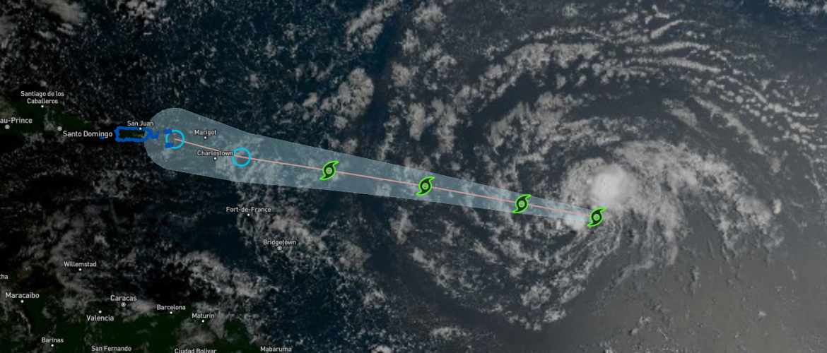
Tropical Storm Dolly continues racing westward across the Atlantic Friday morning, but increasingly hostile conditions are expected to prevent the storm from strengthening significantly. In fact, Dolly could lose its tropical cyclone structure before reaching the Lesser Antilles this weekend.
As of the 5:00 AM AST advisory Friday, Dolly remained a minimal tropical storm with maximum sustained winds near 40 mph. The storm was moving quickly westward at approximately 24 mph.
While Dolly itself may not survive the trip across the Atlantic as an organized tropical cyclone, its moisture could still bring heavy rainfall and potential flooding to portions of the Caribbean this weekend and early next week.
Dolly Remains a Weak Tropical Storm
Satellite imagery overnight showed little overall change in Dolly. A relatively small area of thunderstorms remained near and northeast of the center, while dry air continued working into the southern portion of the circulation.
There were also indications that Dolly's low-level circulation may already be becoming less defined.
This is important because Dolly is facing several factors working against strengthening.
Increasing southerly wind shear, dry air and the storm's rapid forward movement should make it difficult for Dolly to organize or intensify significantly.
Current forecast guidance instead indicates that Dolly should gradually weaken.
Moving Quickly Across the Atlantic
Dolly is moving rapidly westward at around 24 mph as a strong subtropical ridge to its north continues steering the system across the tropical Atlantic.
That quick forward motion is expected to continue.
Weak tropical systems moving this quickly can sometimes be difficult for forecast models to handle, and some models have a tendency to move them too slowly. Because of that, the official forecast favors a relatively fast westward track.
Regardless of its exact classification, Dolly or its remnants should approach the Lesser Antilles this weekend.
Dolly Could Dissipate Before Reaching the Islands
The latest forecast continues to suggest Dolly may not remain a tropical storm for very long.
Increasing wind shear should disrupt the storm's thunderstorms, while dry air continues entering the circulation. Combined with Dolly's fast movement, these conditions are expected to cause the system to gradually weaken.
Forecast guidance indicates Dolly could eventually lose its closed circulation and degenerate into a trough of low pressure before reaching the Lesser Antilles.
That means Dolly may no longer technically be a tropical cyclone when it reaches the region.
However, losing the name "Tropical Storm Dolly" does not mean the weather impacts disappear.
Heavy Rain Could Still Become the Main Concern
The biggest concern for the Caribbean may ultimately be rainfall rather than wind.
Moisture associated with Dolly or its remnants could begin affecting the Leeward Islands late Saturday into Sunday.
Heavy rainfall could produce flash flooding, particularly across mountainous terrain where rainfall can quickly run off into valleys and low-lying areas.
Rainfall impacts could then spread farther west.
The Virgin Islands, Puerto Rico and Hispaniola could potentially experience impacts from Dolly's moisture Sunday into Monday.
Residents and visitors across these areas should continue monitoring the forecast even if Dolly weakens or dissipates before arriving.
No Threat to North Carolina
Dolly currently poses no threat to North Carolina or the United States mainland.
The storm is expected to continue rapidly westward toward the Caribbean while weakening.
For North Carolina, Dolly is something to watch from a tropical weather standpoint, but there is currently no indication that the system will become a concern for our area.
What I'm Watching
The most important part of Dolly's forecast over the next couple of days will not necessarily be whether the system maintains tropical storm status.
Instead, I'll be watching how much tropical moisture survives as the circulation approaches the Caribbean.
Dolly could weaken into a trough before reaching the Lesser Antilles, but that moisture could still produce periods of heavy rainfall and localized flash flooding across portions of the islands.
I'll continue monitoring Dolly along with the rest of the Atlantic as we move deeper into the heart of hurricane season.