
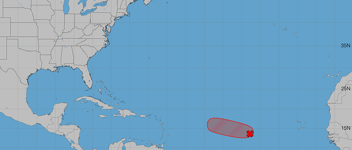
AL96 Nears Tropical Storm Formation in the Central Atlantic, But Development Window Is Short
An area of low pressure in the central tropical Atlantic has become significantly better organized, and we could have another named tropical storm before the end of the day Thursday.
As of the 8 AM Tropical Weather Outlook Thursday, August 27, the National Hurricane Center is monitoring Invest 96L (AL96), located roughly midway between the coast of Africa and the Windward Islands.
Satellite and microwave imagery overnight showed the system becoming better organized. If that trend continues, the National Hurricane Center could begin issuing advisories on a tropical storm later today.
Development Chances Now at 90%
The development probabilities for AL96 have increased substantially:
- Formation chance through 48 hours: 90%
- Formation chance through 7 days: 90%
Those probabilities indicate that tropical cyclone formation is considered highly likely.
However, there is an important part of this forecast: whatever develops may not last very long.
A Short-Lived Tropical Storm Is Possible
While conditions are currently supportive enough for AL96 to organize, the environment ahead of the system is expected to become increasingly unfavorable beginning Friday.
That means AL96 has a relatively narrow window to become a tropical storm.
If organization continues today, the system could meet the requirements for tropical storm classification and receive a name. But hostile environmental conditions beginning Friday are expected to significantly limit additional development and could quickly weaken or disrupt the system.
The National Hurricane Center specifically indicates that these deteriorating conditions will likely end the system's opportunity for further development.
Why a 90% Chance Doesn't Mean a Major Storm
It's important to put the 90% development probability into context.
That number represents the likelihood that the disturbance will become a tropical depression or tropical storm. It does not mean there is a 90% chance of a hurricane, nor does it indicate how strong the system could ultimately become.
In this case, the development window appears particularly short. AL96 could become a tropical storm today and then encounter an environment increasingly hostile to maintaining that organization.
That's why the National Hurricane Center is already describing the potential tropical storm as possibly short-lived.
Any Threat to the United States?
At this point, AL96 does not represent an immediate threat to North Carolina or the United States.
The disturbance remains far out over the central tropical Atlantic, roughly midway between Africa and the Windward Islands. More importantly, the expected deterioration in environmental conditions beginning Friday could substantially limit how long the system survives.
There is no reason for anyone in North Carolina to be concerned about direct impacts from AL96 based on the information available Thursday morning.
I'll continue watching it, particularly to see whether the National Hurricane Center begins issuing advisories later today.
Atlantic Hurricane Season Remains Active
Even if AL96 ultimately becomes a short-lived system, its rapid organization is another reminder that we are moving through the heart of Atlantic hurricane season.
Late August through September is historically one of the most active portions of the season. Atmospheric and oceanic conditions across the tropical Atlantic can allow disturbances coming off Africa to organize quickly when they encounter a favorable environment.
Not every disturbance will become a hurricane, and not every named storm will threaten land. But this is the time of year when it's worth regularly checking the tropics.
What I'm Watching Next
The immediate question is whether AL96 becomes organized enough today for the National Hurricane Center to classify it as a tropical cyclone and begin advisories.
I'll be watching:
- Whether a sufficiently organized circulation develops
- Whether tropical storm advisories are initiated later today
- How much strengthening can occur before conditions deteriorate Friday
- How quickly the system weakens once it encounters the less favorable environment
For now, development is highly likely, but longevity is not.
I'll continue monitoring the Atlantic and provide updates if AL96 becomes a named tropical storm or there are meaningful changes to the forecast.
Rowan County Weather & Regional Forecasts