
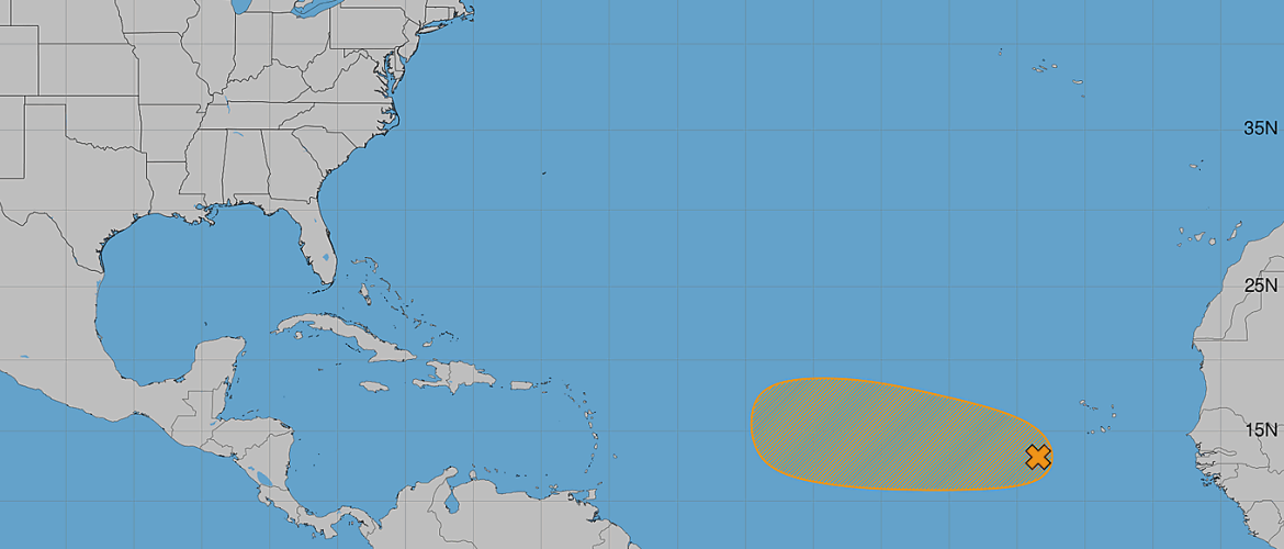
AL96 Has a 60% Chance of Tropical Development in the Atlantic
The tropical Atlantic remains active this Wednesday morning, with an area of low pressure southwest of the Cabo Verde Islands continuing to show the potential to become the Atlantic's next tropical depression.
The system, designated Invest AL96, currently has a 60% chance of tropical development during the next 48 hours and a 60% chance through the next seven days.
While development is becoming increasingly possible, there is an important part of the forecast to keep in mind: AL96 may have a relatively limited window to organize before environmental conditions become less favorable this weekend.
Where Is AL96?
AL96 is an area of low pressure associated with a tropical wave located a few hundred miles southwest of the Cabo Verde Islands in the eastern tropical Atlantic.
As of Wednesday morning, showers and thunderstorms associated with the disturbance remain disorganized.
The system is expected to continue moving generally westward to west-northwestward across the eastern and central tropical Atlantic during the next several days.
Tropical Depression Could Form Soon
Environmental conditions surrounding AL96 are somewhat favorable for additional organization over the next couple of days.
If thunderstorms become better organized around a defined low-level circulation, a tropical depression could form as soon as the next day or two.
Current development chances are:
Through 48 hours: 60% — Medium
Through 7 days: 60% — Medium
The fact that the probabilities are the same through both periods is important. It indicates that the system's best opportunity for development appears to be relatively soon rather than later in the seven-day forecast period.
The Development Window May Be Limited
AL96 does not necessarily have an open path toward continued strengthening.
Environmental conditions are forecast to become less favorable by this weekend, potentially bringing an end to the system's opportunity for tropical development.
That makes the next 48 hours particularly important.
I'll be watching whether AL96 can establish a better-defined circulation and whether thunderstorm activity becomes more concentrated around the center of the disturbance.
If that organization happens quickly enough, we could see a tropical depression form over the central tropical Atlantic.
If organization remains slow, the system could encounter the less favorable environment this weekend before development occurs.
What Does This Mean for North Carolina?
At this stage, AL96 is far out in the tropical Atlantic and there is no immediate threat to North Carolina.
It is much too early to determine whether the system will eventually have any impact on the United States.
Before talking about potential impacts, AL96 first has to organize into a tropical cyclone. Its eventual track will also depend on atmospheric steering patterns several days down the road.
For now, this is a system to monitor rather than worry about.
What I'm Watching Next
There are several things I'll be paying attention to during the next couple of days:
- Whether a well-defined circulation develops
- Whether thunderstorms become more organized around the center
- How quickly AL96 develops before conditions become less favorable
- Any changes in its west to west-northwest movement
- How forecast models handle the system once, and if, a defined circulation develops
The 60% development chance makes AL96 worth watching closely, especially because a tropical depression could form within the next day or two.
I'll continue tracking AL96 and provide updates as we learn more about whether this disturbance can organize before conditions become less favorable this weekend.
— Rowan County Weather | Regional Forecasts