
Two Atlantic Systems Being Monitored as AL96 Shows Increasing Development Potential
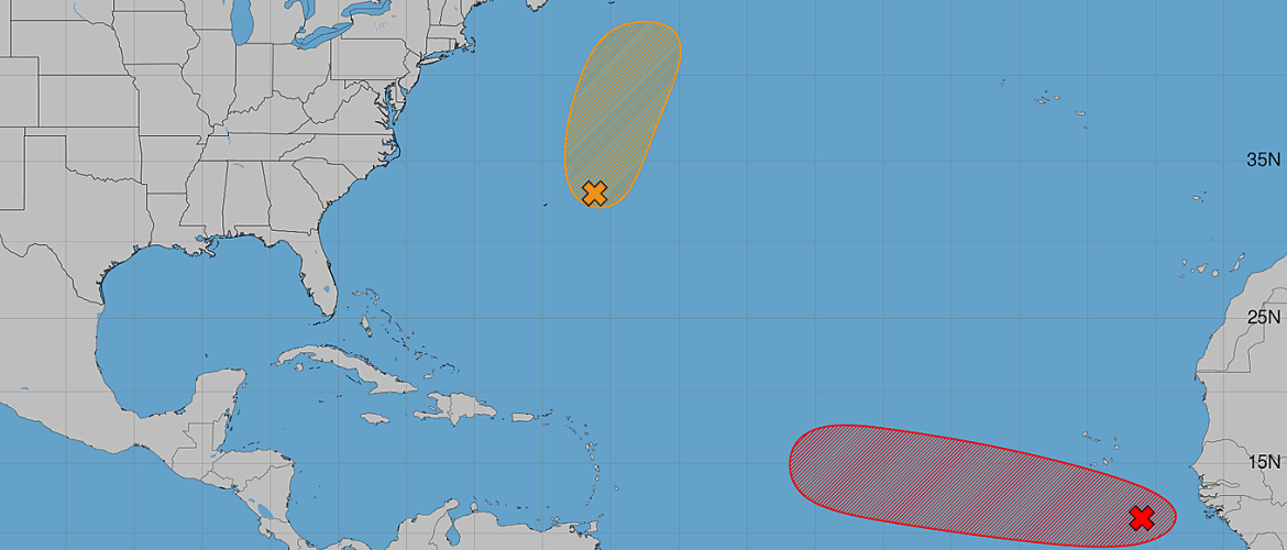
The tropical Atlantic remains active Tuesday morning with two areas being monitored for possible development. While AL95 in the central subtropical Atlantic may have only a limited window to organize, attention is increasingly turning toward AL96 in the eastern tropical Atlantic, where conditions appear more favorable for gradual development.
As of the 2:00 AM Tuesday, August 25 Tropical Weather Outlook, AL96 has a 70 percent chance of developing during the next seven days and is likely to become a tropical depression during the next few days.
AL95: Limited Opportunity for Development
AL95 is an area of low pressure located a couple hundred miles east-northeast of Bermuda.
The system is moving north at approximately 15 to 20 mph. Recent wind data indicates that its circulation remains broad and elongated, while associated shower and thunderstorm activity remains disorganized.
There is still an opportunity for AL95 to become a short-lived tropical depression or tropical storm later today. However, that window appears to be closing quickly.
Environmental conditions are expected to become increasingly hostile tonight and Wednesday, which will likely end AL95's opportunity for tropical development.
Current development probabilities for AL95:
- Formation chance through 48 hours: 40 percent
- Formation chance through 7 days: 40 percent
The fact that the 48-hour and seven-day probabilities are identical highlights the short window this system has to organize. If development does not occur soon, conditions are expected to become unfavorable.
AL96: Development Becoming More Likely
AL96 is the system that deserves more attention over the coming days.
The area of low pressure is centered a few hundred miles south-southeast of the Cabo Verde Islands and is currently producing disorganized showers and thunderstorms.
Unlike AL95, environmental conditions surrounding AL96 appear conducive for gradual development.
The system is expected to move generally west to west-northwest across the eastern and central tropical Atlantic during the next several days. During that time, additional organization is expected, and AL96 is likely to become a tropical depression.
Current development probabilities for AL96:
- Formation chance through 48 hours: 60 percent
- Formation chance through 7 days: 70 percent
Those probabilities make AL96 the system with the greater development potential in the Atlantic at this time.
What Happens Later This Week?
While conditions currently favor development of AL96, the environment may become less supportive by the weekend.
That makes the next several days important for determining how quickly the system organizes and how strong it may become before encountering potentially less favorable conditions.
There remains considerable uncertainty this far out, particularly regarding the system's eventual track and intensity.
At this stage, AL96 is still only an area of low pressure. Even if it becomes a tropical depression during the next few days, it is much too early to determine whether the system will eventually pose a threat to the United States or any particular land area farther west.
No Reason to Focus on Long-Range Tracks Yet
As AL96 receives more attention, computer-model maps and individual model runs will likely begin circulating widely on social media.
Those long-range projections should be viewed cautiously.
Until a well-defined tropical cyclone develops, forecast models may have difficulty determining exactly where the center of circulation is located. Small differences in the system's organization, surrounding atmospheric pattern and future intensity can lead to significant differences in long-range tracks.
The important information right now is that development is becoming increasingly likely and the system will need to be monitored as it moves across the tropical Atlantic.
What I'm Watching
There are two different situations unfolding in the Atlantic Tuesday morning.
AL95 has a brief opportunity to become a tropical depression or storm before environmental conditions become increasingly hostile.
AL96 has a better opportunity for gradual development and is likely to become a tropical depression during the next few days as it moves west to west-northwest across the tropical Atlantic.
For now, there is no immediate tropical threat to North Carolina from either system.
I'll continue monitoring AL95 and AL96 for changes in organization, development probabilities and, particularly with AL96, any indications of how the steering pattern may evolve later this week.
Current development chances:
AL95: 40% through 48 hours | 40% through 7 days
AL96: 60% through 48 hours | 70% through 7 days
Stay with Rowan County Weather and Regional Forecast for updates as the Atlantic tropical pattern continues to evolve.