
Atlantic Tropics Becoming More Active With Three Areas to Watch
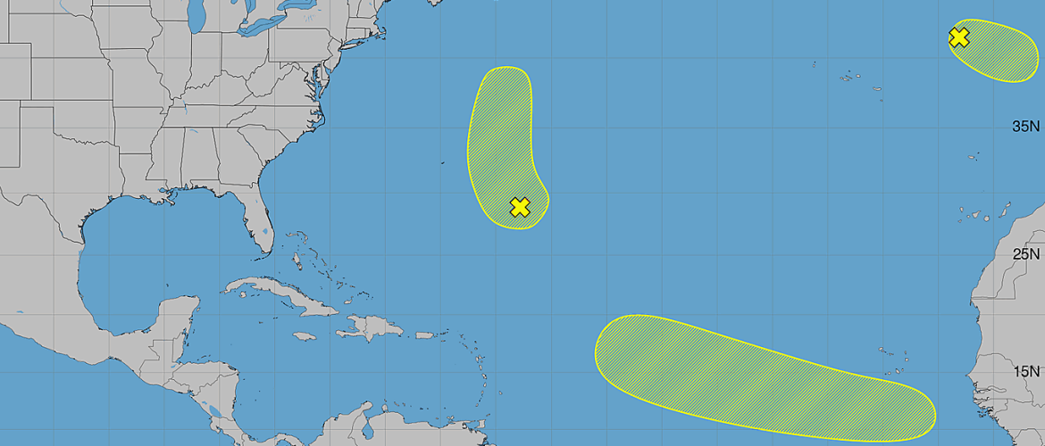
The Atlantic basin is showing signs of increased tropical activity as we move deeper into the heart of hurricane season. As of Saturday morning, August 22, three areas are being monitored for possible tropical or subtropical development.
None of the three systems poses an immediate threat to North Carolina, but one tropical wave expected to emerge from Africa early next week will be worth watching as it begins a journey across the tropical Atlantic.
Northeastern Atlantic System — 20% Development Chance
A strong non-tropical area of low pressure is located several hundred miles west of Portugal.
The system could acquire tropical or subtropical characteristics later Saturday or Sunday as it moves east-southeast at approximately 10 to 15 mph toward Portugal and northwestern Spain.
Development opportunities will be limited. Environmental conditions are expected to become unfavorable by Sunday night, bringing the window for tropical or subtropical development to an end.
Development chances:
- Next 48 hours: 20%
- Next 7 days: 20%
Because of its location and expected movement toward Europe, this system is not a concern for the United States.
Central Subtropical Atlantic — 20% Development Chance
A trough of low pressure is located a few hundred miles east of Bermuda and is currently producing disorganized shower activity.
Development, if it occurs, is expected to be slow. The disturbance should drift westward through Sunday before beginning to accelerate northward early next week.
Development chances:
- Next 48 hours: 10%
- Next 7 days: 20%
The expected turn toward the north will be important to watch. At this point, there is no indication of an immediate threat to North Carolina.
Eastern Tropical Atlantic Wave — 30% Development Chance
The third area is the one I'll be paying closer attention to over the coming week.
A tropical wave is expected to move off the west coast of Africa on Monday. An area of low pressure could develop in association with the wave shortly after it enters the Atlantic.
Conditions could then support additional organization as the disturbance moves westward at approximately 15 to 20 mph across the eastern and central tropical Atlantic through the end of next week.
Development chances:
- Next 48 hours: Near 0%
- Next 7 days: 30%
This system is still several days away from even entering the Atlantic, so there is considerable uncertainty regarding its eventual development, strength and track.
At this stage, there is no reason to speculate about potential impacts to the United States or North Carolina. The important point is that this wave will have an opportunity to develop while traveling westward across the Atlantic, making it something worth monitoring next week.
No Immediate Tropical Threat to North Carolina
Despite having three areas highlighted across the Atlantic, there is currently no immediate tropical threat to Rowan County or North Carolina.
The northeastern Atlantic system is moving toward Europe, while the disturbance east of Bermuda is expected to eventually accelerate northward. The tropical wave coming off Africa is much farther away and will require several days of monitoring before there is any meaningful indication of where it could eventually go.
We're Entering the Heart of Hurricane Season
Seeing an increase in disturbances across the Atlantic isn't unusual for late August.
Atlantic hurricane activity historically increases considerably during the second half of August and into September as ocean temperatures remain warm and atmospheric conditions become increasingly favorable across portions of the tropical Atlantic.
That means tropical waves emerging from Africa deserve more attention during the coming weeks, even when their initial development chances are relatively low.
For now, there is nothing threatening North Carolina. I'll continue monitoring all three areas, with particular attention on the tropical wave expected to emerge from Africa Monday.
As always, I'll keep you updated if anything changes that could eventually become relevant to North Carolina.
— Steve | Rowan County Weather