
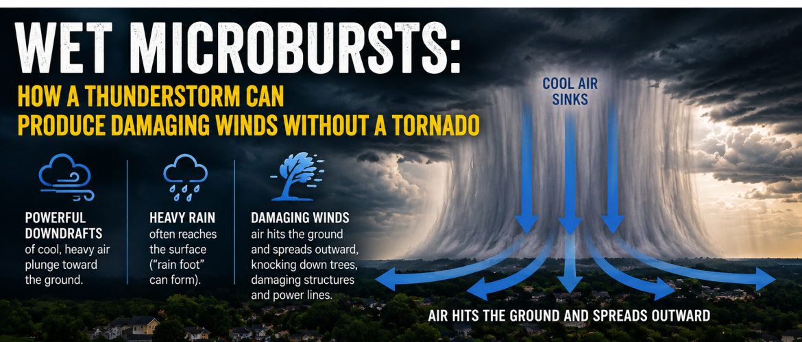
Wet Microbursts: How a Thunderstorm Can Produce Damaging Winds Without a Tornado
When thunderstorms develop on a hot and humid summer afternoon in North Carolina, tornadoes aren't the only source of potentially damaging winds.
One of the lesser-known threats is a wet microburst — a sudden blast of powerful wind that descends from a thunderstorm and spreads outward when it reaches the ground.
These events can happen quickly, affect a relatively small area and sometimes cause damage that people initially assume was caused by a tornado.
What Is a Microburst?
A microburst is a type of downburst produced by rapidly descending air inside a thunderstorm.
Instead of air rotating upward as it does in a tornado, a microburst involves air accelerating downward toward the ground. When that air reaches the surface, it spreads rapidly outward in different directions.
The National Weather Service defines a microburst as a convective downdraft affecting an outflow area less than about 2.5 miles wide, with peak winds generally lasting less than five minutes.
That makes a microburst relatively small and short-lived, but it certainly doesn't mean it is weak.
Extreme microbursts have produced winds approaching 150 mph, although most are considerably weaker. Even much lower wind speeds can bring down trees and power lines or damage structures.
What Makes a Microburst "Wet"?
Microbursts are generally described as either wet or dry depending on the amount of precipitation reaching the ground.
A wet microburst occurs with heavy precipitation at the surface. These are particularly relevant in the humid environment of the southeastern United States, where summertime thunderstorms frequently contain tremendous amounts of moisture.
You may see an intense shaft of rain descending from a thunderstorm shortly before the strongest winds arrive.
A feature sometimes called a rain foot can also develop. This happens when the rain shaft appears to spread or bow outward near the ground as powerful winds push precipitation horizontally away from the point where the downdraft reaches the surface.
How Does One Develop?
Inside a thunderstorm, powerful updrafts carry air, water droplets and ice upward.
Eventually, some of that air begins descending.
Several processes can strengthen the downdraft, including the weight of precipitation within the storm — known as precipitation loading — along with cooling associated with evaporation and other processes.
Think about pouring water downward onto a hard surface.
The water doesn't simply stop when it hits. It splashes outward.
A microburst behaves somewhat similarly.
Air plunges toward the surface, hits the ground and then rapidly spreads horizontally away from the impact point.
That outward surge produces the potentially damaging straight-line winds.
Why Can the Damage Look Like a Tornado?
After a severe thunderstorm, it's common to hear reports that a tornado "must have come through" because trees are down or structures were damaged.
But significant wind damage does not automatically mean there was a tornado.
A tornado contains a violently rotating column of air extending from a thunderstorm to the ground.
A microburst produces primarily diverging straight-line winds as air strikes the surface and spreads outward.
Both can produce significant damage.
The difference often becomes clearer when meteorologists and storm survey teams examine the damage pattern. Downburst winds tend to push debris outward or generally in the same direction, while tornado damage can display the convergent and rotational characteristics associated with a tornado's circulation.
Microbursts Can Be Extremely Localized
One of the most interesting things about microbursts is their small size.
One neighborhood could experience powerful winds capable of knocking down trees while another community only a few miles away experiences ordinary rain and thunder.
That can make storm reports seem confusing.
Someone might report significant wind damage while people nearby wonder what happened because conditions at their homes weren't nearly as severe.
The localized nature of microbursts is one reason thunderstorms should never be judged solely by what is happening at your location at that particular moment.
They Can Develop Quickly
Microbursts can also be challenging because they don't necessarily provide the same visual clues people associate with tornadoes.
There may be no funnel cloud and no obvious rotation.
Instead, you could notice an increasingly intense precipitation core followed by a sudden surge of wind.
The strongest winds generally occur shortly after the descending air reaches the ground and begins spreading outward.
That transition can happen rapidly.
Why They're Especially Dangerous to Aviation
Microbursts aren't only a concern for people on the ground.
They are particularly dangerous to aircraft because they can create dramatic changes in wind speed and direction over a very short distance — known as wind shear.
An aircraft approaching or departing an airport can encounter rapidly changing winds as it passes through different portions of a microburst.
Improved Doppler radar, forecasting and aviation technology have helped meteorologists and pilots better recognize this hazard, but microbursts remain an important aviation concern.
What Should You Do?
Treat damaging thunderstorm winds seriously regardless of whether a tornado is involved.
When a Severe Thunderstorm Warning is issued for your location, move indoors and away from windows. Avoid sheltering beneath trees, and remember that falling trees and branches are among the significant hazards associated with strong thunderstorm winds.
If you're driving, be prepared for rapidly changing visibility in torrential rainfall along with sudden strong crosswinds.
And if you see an intense rain shaft approaching, don't assume that "it's only rain." Powerful winds could be accompanying it.
Not Every Damaging Storm Is a Tornado
Tornadoes understandably receive considerable attention when severe weather threatens North Carolina, but straight-line thunderstorm winds can also cause significant damage.
Wet microbursts are a perfect example.
They can develop quickly, produce torrential rainfall and unleash a concentrated burst of powerful wind across a small area — all without producing a tornado.
It's another reason to take severe thunderstorms seriously and stay weather aware whenever storms are developing across the region.
Rowan County Weather will continue providing radar updates and information when thunderstorms threaten Rowan County and the surrounding area.