
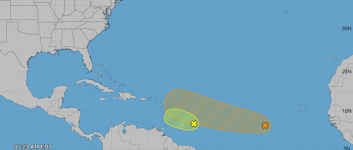
Atlantic Update: AL94 Development Chances Increase While AL92 Weakens
Two tropical waves continue to be monitored across the Atlantic Basin Friday morning, but their prospects for development are moving in opposite directions.
The system designated AL92, now approaching the Windward Islands, is becoming less likely to develop. Farther east, AL94 continues moving across the central tropical Atlantic and now has a 50 percent chance of developing during the next seven days.
Neither system currently poses a threat to the Carolinas, but AL94 will be the system to watch over the coming days.
AL92: Development Chances Continue to Decrease
AL92 is a tropical wave located about 400 miles east of the Windward Islands Friday morning.
The system continues to produce a large area of showers and thunderstorms along with gusty winds. However, atmospheric conditions along its path are becoming increasingly unfavorable for tropical development.
AL92 is moving into an environment containing stronger upper-level winds and dry air. Those conditions should make it increasingly difficult for the system to organize.
As of the 8 a.m. Friday Tropical Weather Outlook, AL92 has a:
- 20 percent chance of formation during the next 48 hours
- 20 percent chance of formation during the next seven days
While tropical development is becoming unlikely, the wave can still produce impacts as it approaches the islands.
Portions of the Lesser Antilles could experience gusty winds and periods of heavy rainfall tonight and Saturday as the tropical wave moves through the region.
AL94: Tropical Depression Could Form
Farther east, attention is increasingly turning toward AL94.
This tropical wave is located over the central tropical Atlantic, more than 1,000 miles west of the Cabo Verde Islands.
Showers and thunderstorms associated with the wave remain disorganized Friday morning, meaning the system does not yet have the structure necessary to become a tropical depression.
Unlike AL92, however, environmental conditions surrounding AL94 are expected to remain generally favorable for gradual development.
As the wave moves westward to west-northwestward across the central tropical Atlantic, additional organization is possible.
A tropical depression could form this weekend or early next week.
The latest development probabilities for AL94 are:
- 30 percent during the next 48 hours
- 50 percent during the next seven days
That places AL94 in the medium development category through the next week.
What Happens Next With AL94?
AL94 remains far out in the Atlantic, so there is considerable uncertainty regarding what ultimately happens with the system.
The first question is whether the tropical wave can organize enough to develop a defined circulation and become a tropical depression.
If development occurs, attention will then turn toward the strength and position of the atmospheric steering features surrounding the system. Those features will determine its eventual track.
At this distance and this early in the development process, it is far too soon to determine whether AL94 will eventually affect the United States or any particular location.
There is also no reason to focus on individual long-range model tracks at this stage. Those projections can change considerably before a tropical system develops.
No Threat to Rowan County at This Time
There is currently no tropical threat to Rowan County or the Carolinas from either AL92 or AL94.
AL92 is approaching the Lesser Antilles while becoming less likely to develop, and AL94 remains more than 1,000 miles west of the Cabo Verde Islands.
The more important system to monitor over the next several days will be AL94 because its environment appears more favorable for development.
With the seven-day formation probability now at 50 percent, I will continue following its organization and movement across the central tropical Atlantic.
The Atlantic hurricane season is entering a more active portion of the calendar, so we'll continue keeping an eye on anything that develops across the basin.
Rowan County Weather will continue to provide updates on AL94 and any other tropical systems that could eventually become relevant to the Carolinas.