
Heat Builds Across Rowan County as Strong to Severe Storms Are Possible Today
Rowan County is heading into a hot and increasingly humid stretch of August weather, but before the heat becomes the dominant story this week, there is also a risk for strong to severe thunderstorms this afternoon and evening.
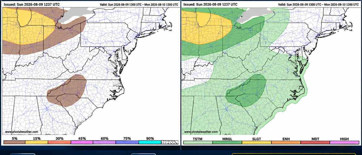
The Storm Prediction Center has placed Rowan County within a Marginal Risk, Level 1 of 5, for severe thunderstorms today.
The primary concern with any stronger thunderstorms will be damaging wind gusts.
5 Percent Damaging Wind Risk
Rowan County is also included within the 5 percent probability area for damaging thunderstorm winds.
A 5 percent probability does not mean there is a 5 percent chance of a thunderstorm occurring. It means there is a 5 percent probability of damaging thunderstorm winds occurring within 25 miles of any given point inside the outlined area during the outlook period.
While that percentage may sound small, it is enough to warrant the Marginal Risk designation and indicates that isolated severe thunderstorms are possible.
What Could Make Some Storms Strong Today?
The atmosphere is expected to become quite unstable during the afternoon as temperatures climb into the lower 90s.
Available instability could become substantial during peak heating. At the same time, wind shear remains relatively modest, which should limit the potential for widespread or highly organized severe thunderstorms.
The setup does, however, favor the possibility of strong downdrafts.
Thunderstorms developing in a hot and humid environment can become loaded with precipitation. As that rain-cooled air accelerates toward the ground, it can produce a powerful burst of wind when it reaches the surface and spreads outward.
These wet microbursts or strong thunderstorm downbursts can occasionally produce damaging winds even when storms are relatively short-lived.
Locally heavy rainfall will also be possible. Slow-moving or repeatedly developing thunderstorms could produce isolated flooding problems.
Not Everyone Will See a Storm
Today's severe weather risk does not mean everyone in Rowan County will experience thunderstorms.
Storm coverage is expected to be scattered across the broader region, with greater coverage closer to the mountains. Rowan County could spend much of the day without rain.
However, any storm that does develop over or move into the county will need to be watched because of the potential for strong wind gusts and torrential rainfall.
Thunderstorm activity should diminish after sunset.
Heat Becomes the Bigger Story This Week
Outside of today's thunderstorm potential, increasingly hot and humid weather will become the main story.
Today's high in Rowan County is expected to reach around 92 degrees, with heat index values potentially approaching 100 degrees.
Monday will bring another high near 92 degrees, but increasing humidity could push the heat index as high as 101 degrees.
Temperatures then climb even higher:
Tuesday: High near 94 degrees
Wednesday: High near 94 degrees
Thursday: High near 94 degrees
Overnight temperatures will provide relatively little relief, with lows generally around 72 degrees.
Afternoon heat index values could reach the upper 90s to around 100 to 103 degrees at times during the workweek.
Some Uncertainty Later This Week
Thunderstorm coverage should generally decrease after Monday, but there is still some uncertainty surrounding the middle and latter portions of the week.
Northwest flow developing aloft could eventually allow organized clusters of thunderstorms to travel toward the Carolinas. Whether Rowan County ends up in the path of one of these thunderstorm complexes remains uncertain.
Cloud cover or thunderstorms could also have a significant influence on temperatures and heat index values on any particular afternoon.
By next weekend, there are indications that a boundary could move southward and eventually provide some relief from the heat.
What I'm Watching
For today, the focus will be on whether thunderstorms can develop or move into Rowan County during the afternoon and evening. Any stronger storm could produce damaging wind gusts and very heavy rainfall.
Beyond today, attention turns increasingly toward the heat and humidity, with several consecutive afternoons in the 90s and heat index values potentially reaching or exceeding 100 degrees.
I'll be monitoring radar throughout the afternoon and will provide updates if thunderstorms begin approaching or developing across Rowan County.