

Heavy Downpours Could Lead to Localized Flooding Across Rowan, Davie, and Davidson Counties Today
Published: Tuesday, August 4, 2026
Residents across Rowan, Davie, and Davidson counties should be prepared for another active weather day as showers and thunderstorms become more widespread through the afternoon and evening. While not everyone will experience heavy rainfall, storms that do develop will be capable of producing torrential downpours that could result in localized flooding.
Recent rainfall has left the ground saturated across much of the region, meaning it won't take long for water to collect on roadways and in low-lying areas. The greatest concern today will be flooding in poor drainage locations, urban areas, and spots that receive repeated rounds of thunderstorms.
Timing
A few showers are possible this morning, but rain coverage will increase late this morning and continue through the afternoon and evening. The heaviest rainfall is expected during the afternoon hours as daytime heating combines with abundant moisture already in place across the Carolinas.
Although storms will gradually diminish later this evening, a few showers could linger into the overnight hours.
Flooding Threat
Today's atmosphere contains an unusually high amount of moisture for early August. Combined with slow-moving thunderstorms, this setup favors periods of very heavy rainfall over a short amount of time.
If storms repeatedly move across the same locations, localized flooding may develop quickly, especially in:
- Poor drainage areas
- Low-lying roads
- Urban locations
- Small creeks and streams
Motorists should remain alert for water covering roadways. Never attempt to drive through flooded roads, as water depth can be difficult to judge and road damage may be hidden beneath the surface.
Strong Storms Also Possible
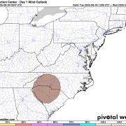
While widespread severe weather is not expected, a few thunderstorms could become strong this afternoon and evening.
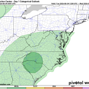
The primary hazard will be isolated damaging wind gusts capable of bringing down small tree limbs or causing isolated power outages. The Storm Prediction Center has placed portions of central North Carolina in a Marginal Risk (Level 1 of 5) for severe thunderstorms, including Davidson County and areas just to our east. Rowan and Davie counties remain outside the outlook, but a few stronger storms are still possible.
Looking Ahead
Above-average rain chances will continue through Wednesday before the weather pattern begins transitioning later this week.
By Thursday through the weekend, temperatures will gradually climb back into the mid-80s, and rain chances will become more typical for August, with scattered afternoon and evening thunderstorms each day instead of widespread rainfall.
Continue checking back with Rowan County Weather throughout the day for forecast updates, radar updates, and any watches or warnings that may be issued as storms develop.