

Wednesday Severe Weather Threat: Damaging Winds and Heavy Rain Possible Across the Rowan County Weather Coverage Area
A more active weather pattern is expected to develop on Wednesday as a cold front approaches the Carolinas, bringing an increased threat for strong to severe thunderstorms, damaging wind gusts, and locally heavy rainfall across the Rowan County Weather coverage area.
After another hot and humid day on Tuesday, conditions will become increasingly favorable for thunderstorm development Wednesday afternoon and continue into Wednesday night.
Slight Risk Covers Nearly the Entire Coverage Area
The Storm Prediction Center has placed virtually all of Rowan, Davie, and Davidson counties in a Slight Risk (Level 2 of 5) for severe thunderstorms on Wednesday.
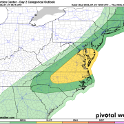
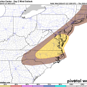
The primary concern will be damaging straight-line wind gusts, with a 15% probability of severe winds within 25 miles of any given location across nearly the entire coverage area.
Tornado Risk is More Limited
While damaging winds remain the primary hazard, there is also a 2% tornado risk across portions of the area.
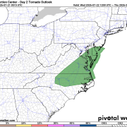
Based on the latest outlook, the tornado risk includes:
- All of Davidson County
- The eastern border of Davie County
- The southeastern corner of Rowan County
Although the tornado threat is relatively low, it is not zero. Any stronger storm interacting with the approaching boundary could briefly rotate, especially during the late afternoon and evening hours.
Heavy Rainfall May Become a Bigger Concern
In addition to severe weather, thunderstorms will be capable of producing torrential rainfall.
Forecast guidance indicates storms may repeatedly move over the same locations Wednesday evening and Wednesday night, increasing the potential for localized flooding, especially in low-lying and poor drainage areas.
Rainfall totals of 1 to 2 inches will be possible in many locations, with isolated higher amounts where storms train over the same area.
Timing
Current indications suggest:
- Tuesday: Mostly dry with only isolated storms possible.
- Wednesday Afternoon (after 2-3 PM): Storms begin developing and increasing in coverage.
- Wednesday Evening through Overnight: Highest confidence for widespread showers and thunderstorms, including the potential for severe weather and heavy rainfall.
- Thursday: Showers and thunderstorms continue as the front slowly moves south, but the severe weather threat should decrease.
Primary Hazards
Damaging wind gusts of 50-70 mph
Torrential rainfall and localized flooding
Frequent lightning
A low, but non-zero tornado risk across portions of Davidson, eastern Davie, and southeastern Rowan counties
Cooler Weather Follows
The good news is this cold front will finally bring relief from the recent stretch of hot and humid weather.
High temperatures, which have been in the lower to middle 90s, are expected to fall into the mid to upper 70s Thursday through Saturday, with much more comfortable conditions.
Rowan County Weather Will Be Monitoring the Situation
Forecast details will continue to be refined over the next 24 hours as confidence increases on the exact timing and placement of the strongest storms.
Be sure to check back with Rowan County Weather throughout Tuesday and Wednesday for the latest forecast updates, radar coverage, and any watches or warnings that may be issued.