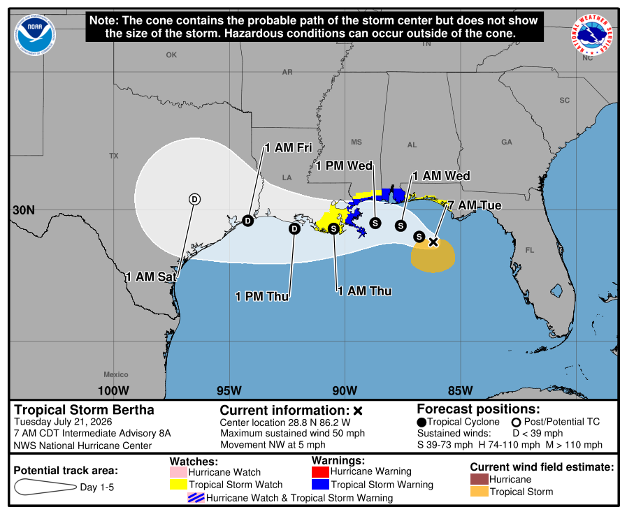
Tropical Storm Bertha Continues to Strengthen, But Increasing Wind Shear Expected to Limit Development
Tropical Storm Bertha has strengthened overnight in the northern Gulf, but increasingly hostile atmospheric conditions are expected to limit any significant additional intensification as the storm approaches the central Gulf Coast.
As of the National Hurricane Center's 4:00 AM CDT advisory, Bertha has maximum sustained winds of 50 mph (45 knots) and a minimum central pressure of 998 mb. Aircraft reconnaissance data confirmed the storm strengthened overnight before increasing wind shear began affecting its structure.
Storm Becoming Less Organized
Although Bertha has become stronger, satellite imagery and reconnaissance data indicate the storm's circulation is becoming increasingly tilted due to strong northeasterly wind shear. The low-level center is now exposed north of the deepest thunderstorms, a sign that the storm is struggling to maintain a well-organized structure.
Occasional bursts of thunderstorms are expected to continue today, but the unfavorable environment should prevent significant strengthening.
Slow Movement Continues
Bertha is moving slowly toward the northwest at around 5 mph (4 knots).
The storm is expected to continue a slow northwest to west-northwest track before gradually turning more westward during the middle of the week. However, there remains some uncertainty because thunderstorms developing on the southwest side of the storm could influence the exact track.
Some forecast models even suggest Bertha could weaken enough to lose its tropical cyclone status later this week as it encounters stronger wind shear and begins interacting with land along the Gulf Coast.
Gradual Weakening Expected
While Gulf waters remain warm enough to support tropical development, the surrounding atmosphere is becoming much less favorable.
Wind shear is expected to increase through the next 24 hours while drier air works into the circulation. As a result, only slight strengthening is expected today before Bertha begins a gradual weakening trend.
By the time the system moves near or along the Louisiana Gulf Coast, it may become increasingly elongated or even degenerate into an open trough if the hostile environment overwhelms the storm's circulation.
Rainfall and Wind Will Be Uneven
Because of the strong wind shear, Bertha is expected to have a very asymmetric structure.
The heaviest rainfall and strongest winds are expected to remain south of the storm's center, meaning impacts will not be evenly distributed around the circulation.
Watches and Warnings
A Tropical Storm Warning remains in effect for portions of the Gulf Coast from Alabama westward into southeastern Louisiana, where tropical storm conditions are expected tonight into Wednesday.
A Tropical Storm Watch remains in effect for portions of the Florida Panhandle, the New Orleans metro area, and parts of coastal Louisiana.
A Storm Surge Watch is also in effect for portions of the Alabama, Mississippi, and southeastern Louisiana coast, where life-threatening storm surge is possible.
Flooding Remains the Greatest Concern
In addition to gusty winds, Bertha is expected to produce heavy rainfall capable of causing flash flooding through Thursday.
The greatest flooding threat extends from the Florida Big Bend westward across the central Gulf Coast into southern Louisiana, with isolated flash flooding also possible farther west along portions of the Texas coast later this week.
No Direct Impacts Expected in North Carolina
At this time, Tropical Storm Bertha is not expected to have any direct impacts on North Carolina, including Rowan, Davie, or Davidson counties.
Rowan County Weather will continue to monitor Bertha and provide updates if the forecast changes or if any indirect impacts become possible later this week.