Tropical Depression Two Slowly Strengthening in the Gulf; No Immediate Threat to North Carolina
Published: July 20, 2026
Tropical Depression Two continues to slowly organize over the Gulf this morning, although it remains a disorganized system with limited thunderstorm activity. The National Hurricane Center reports that reconnaissance aircraft found the depression becoming slightly better organized overnight, prompting an increase in maximum sustained winds to 30 mph.
While gradual strengthening is expected over the next day or two, the system is still struggling with dry air and a broad circulation, which should keep development at a slower pace.
Expected Track
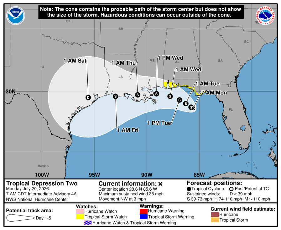
The latest forecast shows Tropical Depression Two drifting slowly northwest before turning west-northwest and eventually west over the next several days.
Current projections bring the center of the system near or along the Gulf Coast, approaching the mouth of the Mississippi River by the middle of the week. Forecast guidance has shifted slightly farther north compared to previous forecasts, but confidence remains lower than average due to the storm's weak structure.
After about 36 hours, increasing wind shear is expected to limit additional strengthening. As the system moves closer to the northern Gulf Coast, interaction with land should also begin to weaken the cyclone.
Expected Strength
The National Hurricane Center expects the depression to strengthen into Tropical Storm Dexter later today.
Additional strengthening is expected through Tuesday before stronger upper-level winds and land interaction begin to weaken the system later this week.
Some forecast models even suggest the system could dissipate shortly after moving inland, highlighting the uncertainty that still exists with its future.
Areas of Concern
A Tropical Storm Watch remains in effect for portions of the Florida Panhandle and the Alabama coastline, where tropical storm conditions could begin as early as tonight and continue into Tuesday.
Residents along the Gulf Coast from Mississippi to Louisiana and Texas should continue monitoring the forecast, as additional watches or warnings could be issued over the next couple of days.
Heavy Rain Remains a Major Concern
Regardless of the system's ultimate strength, heavy rainfall will likely become the greatest hazard.
Flash flooding will be possible through Friday from the western Florida Panhandle westward across coastal Alabama, Mississippi, Louisiana, and portions of the middle Texas coast. Some inland communities could also experience flooding from repeated rounds of heavy rain.
North Carolina Impacts
At this time, Tropical Depression Two poses no direct threat to North Carolina.
The system is expected to remain well to our south and west through the forecast period. While tropical systems can influence weather far from their center, there are currently no indications of direct impacts across Rowan County or the western Carolinas.
As always, Rowan County Weather will continue monitoring the latest forecast trends and provide updates if anything changes.