

Why Today's Storms Could Pack a Punch Across Rowan, Davie, and Davidson Counties
A hot, humid, and increasingly unstable atmosphere is setting the stage for strong to potentially severe thunderstorms across the area this afternoon and evening.
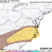
The Storm Prediction Center has placed Rowan, Davie, and Davidson counties in a Slight Risk (Level 2 of 5) for severe thunderstorms today. In addition, all three counties are included in the 15% wind risk area, meaning there's a greater potential for storms capable of producing damaging wind gusts.
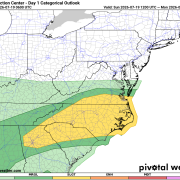
Damaging Wind Is the Main Threat
While lightning and heavy rain will accompany many of today's storms, damaging straight-line winds are expected to be the primary concern.
Some thunderstorms may produce wet microbursts, which occur when heavy rain drags powerful winds toward the ground. These sudden bursts of wind can topple trees, bring down power lines, and cause localized damage similar to a weak tornado—without any rotation.
Wind gusts over 50 mph will be possible with the strongest storms.
Why Storms Could Become Strong
Several ingredients are coming together to create a favorable environment for stronger thunderstorms.
Temperatures will climb into the lower 90s this afternoon while dew points remain in the 70s, pushing heat index values close to 100 degrees. That hot, moisture-rich air will provide plenty of fuel for thunderstorm development.
Atmospheric moisture is also unusually high, with precipitable water values exceeding 2 inches. That means storms will be capable of producing torrential downpours in a short amount of time.
At the same time, a weak cold front approaching from the north will provide the lift needed to trigger thunderstorms, while increasing winds higher in the atmosphere will help storms organize and strengthen.
Timing
Storms could begin developing during the afternoon, but the greatest chance for strong to severe storms will be from late afternoon through this evening, with some activity continuing into the overnight hours.
Not everyone will experience severe weather, but any storm that develops has the potential to strengthen quickly.
Additional Hazards
Along with damaging winds, today's storms may also produce:
- Frequent cloud-to-ground lightning
- Heavy rainfall that could lead to localized flooding
- Brief periods of poor visibility in torrential rain
While tornadoes are not expected to be the primary threat, an isolated spin-up cannot be completely ruled out in any stronger storm.
Stay Weather Aware
If you have outdoor plans today, keep a close eye on the sky and have multiple ways to receive weather warnings.
Remember:
- Secure loose outdoor items before storms arrive.
- Move indoors immediately if thunder is heard.
- Never drive through flooded roadways.
- Charge phones and electronic devices in case scattered power outages occur.
Bottom Line
Today's atmosphere has all the ingredients needed to support stronger thunderstorms across Rowan, Davie, and Davidson counties. The primary threat will be damaging wind gusts, with heavy rain and frequent lightning also expected.
I'll be monitoring radar and storm development throughout the day and will provide updates if stronger storms begin to develop across the area.