Tropical Depression Two Forms in the Gulf; Tropical Storm Watches Issued for Parts of Florida
The National Hurricane Center has officially designated the disturbance that has been moving across the northeastern Gulf as Tropical Depression Two, marking the second tropical cyclone of the 2026 Atlantic hurricane season.
The system has developed a well-defined circulation after several days of gradual organization. While thunderstorm activity remains somewhat disorganized due to dry air wrapping into the system, forecasters say there is now enough persistent convection to classify it as a tropical depression.
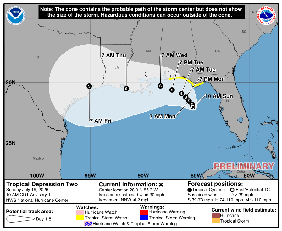
As of the 10:00 a.m. CDT advisory, Tropical Depression Two has maximum sustained winds of 30 mph (25 knots) and a minimum central pressure of 1011 mb.
Slow Strengthening Expected
Forecasters expect Tropical Depression Two to strengthen gradually over the next couple of days.
While nearby dry air and some wind shear are expected to slow development initially, environmental conditions should become more favorable as the system tracks westward later this week. The National Hurricane Center forecasts the depression to become a tropical storm as it approaches the Florida Panhandle.
Exactly how much the system strengthens beyond that will depend on how much time its center spends over the warm waters of the Gulf versus interacting with land along the northern Gulf Coast.
Tropical Storm Watch Issued
A Tropical Storm Watch has been issued for portions of the Florida Panhandle, where tropical storm conditions could develop during the next 24 to 48 hours.
Residents across Alabama, Mississippi, Louisiana, and Texas are also encouraged to monitor the system closely, as additional watches may be required over the next day or two depending on the forecast track.
Heavy Rain and Flash Flooding Threat
Regardless of the system's eventual strength, heavy rainfall is expected to be one of its biggest impacts.
Forecasters are warning that areas of flash flooding will be possible through Thursday along portions of the eastern and central Gulf Coast, including western Florida, southern Alabama, Mississippi, and Louisiana.
Rainfall totals will vary, but repeated rounds of tropical downpours could quickly lead to flooding in low-lying and poor-drainage areas.
Current Track
Tropical Depression Two is moving north-northwest at around 3 mph, although its motion remains somewhat uncertain due to weak steering currents.
The current forecast calls for the system to move slowly toward the Florida Panhandle through Monday before turning west to west-northwest along the northern Gulf Coast during the middle and latter part of the week.
An Air Force Hurricane Hunter aircraft is scheduled to investigate the depression today, providing forecasters with additional information about its structure and intensity.
No Direct Threat to North Carolina
At this time, Tropical Depression Two poses no direct threat to North Carolina. The forecast track keeps the system well to our south along the Gulf Coast.
While Gulf tropical systems can sometimes contribute additional moisture to weather patterns farther inland, there are currently no indications of significant tropical impacts for Rowan, Davie, or Davidson counties.
Rowan County Weather will continue to monitor Tropical Depression Two and provide updates as new advisories are issued throughout the week.