

Why Storm Chances Are Increasing Across the Carolinas This Weekend
After a stretch of hot, mainly dry weather since Monday, the atmosphere is becoming much more favorable for scattered to numerous thunderstorms across the Carolinas this weekend. Rain has been limited for many communities this week, but that pattern is beginning to change as a cold front slowly approaches from the northwest.
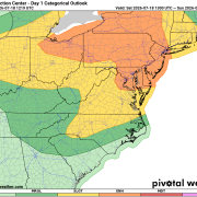
That changing weather pattern has prompted the Storm Prediction Center to place Rowan, Davie, and Davidson counties in a Slight Risk (Level 2 of 5) for severe thunderstorms today.
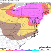
In addition, all three counties are included in the 15% damaging wind probability area, highlighting that strong, potentially damaging straight-line winds are the primary concern if storms develop.
What's Changing?
The weather pattern is beginning to shift after several days of hot and mostly dry conditions. A cold front approaching from the northwest, combined with increasing Gulf and Atlantic moisture, will make the atmosphere much more unstable this weekend.
Unlike the past several afternoons when thunderstorm coverage has been very limited, today's storms are expected to be more numerous. While it won't rain everywhere, more communities are expected to see thunderstorms compared to earlier this week.
The combination of afternoon heating, increasing humidity, and the approaching front will provide the ingredients needed for storms to develop during the afternoon and evening hours.
Damaging Winds Are the Main Threat
The greatest concern today will be damaging straight-line wind gusts.
Strong thunderstorms can produce powerful downdrafts that rush toward the ground before spreading outward, sometimes creating wind gusts capable of:
- Downing trees and large limbs
- Causing scattered power outages
- Damaging outdoor furniture, tents, and other unsecured objects
Frequent cloud-to-ground lightning and torrential rainfall will accompany any stronger storms.
Although a brief tornado cannot be completely ruled out, today's setup strongly favors damaging winds as the primary severe weather hazard.
What Does a Slight Risk Mean?
A Slight Risk (Level 2 of 5) does not mean severe weather is expected everywhere. Instead, it means scattered severe thunderstorms are possible across the region.
For today's outlook, the Storm Prediction Center also places Rowan, Davie, and Davidson counties within a 15% probability area for damaging winds, indicating there is a 15% chance of damaging thunderstorm winds occurring within 25 miles of any given location in the highlighted area.
Not Everyone Will See Rain
Even though storm coverage is expected to increase, this will not be an all-day rain event.
Many communities may remain dry, while others experience a strong thunderstorm lasting 30 to 60 minutes. These summertime storms are often very localized, meaning one neighborhood could receive over an inch of rain while another just a few miles away receives very little.
Sunday Looks Even Wetter
Storm chances increase again on Sunday as the approaching front gets closer to the region.
Forecast rain chances climb into the 60 to 70 percent range Sunday afternoon and Sunday night, making it the wettest period of the weekend. As with today, a few storms could become strong, especially during the afternoon and evening hours.
Looking Ahead
The active weather pattern continues into early next week with daily opportunities for afternoon and evening thunderstorms.
Another cold front is expected to move through on Wednesday, bringing another chance for showers and thunderstorms, with the potential for a few stronger storms before slightly cooler temperatures arrive later in the week.
Bottom Line
Residents of Rowan, Davie, and Davidson counties should remain weather aware this afternoon and evening.
The combination of hot, humid air, an approaching cold front, and increasing atmospheric instability will lead to better thunderstorm coverage than we've seen since the start of the week. While not everyone will experience a storm, those that do could encounter damaging wind gusts, torrential rainfall, frequent lightning, and isolated power outages.
If you have outdoor plans this weekend, keep an eye on the sky and have multiple ways to receive weather warnings should severe thunderstorms develop in your area.