Tropical Disturbance in the Gulf Becoming Better Organized; Development Chances Increase
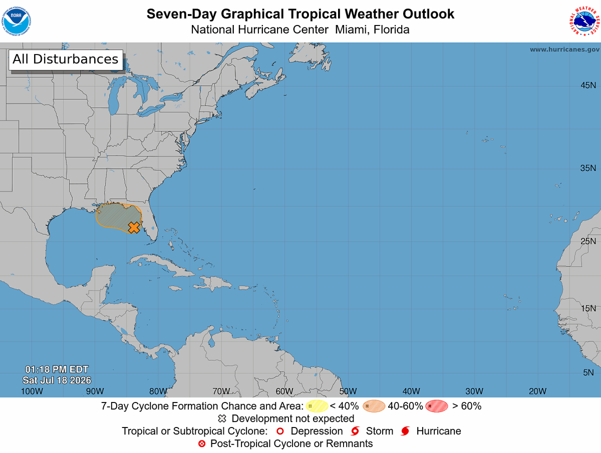
The National Hurricane Center has increased the odds of tropical development for a disturbance in the eastern Gulf after satellite imagery showed signs that a broad area of low pressure is beginning to take shape.
The system has now been designated Invest AL91, allowing forecasters to closely monitor its development using additional computer model guidance and, if necessary, aircraft reconnaissance.
While the system remains poorly organized, gradual strengthening is possible over the next several days as it drifts slowly northward or north-northwestward across the eastern Gulf.
Development Chances Have Increased
Since this morning's outlook, the National Hurricane Center has raised the probability that the system could develop into a tropical depression.
Current development probabilities:
- Next 48 hours: 30% (Low)
- Next 7 days: 40% (Medium)
Although tropical cyclone formation is far from certain, the upward trend in development chances indicates environmental conditions have become somewhat more favorable.
Reconnaissance Aircraft on Standby
An Air Force Reserve Hurricane Hunter aircraft is scheduled to investigate the disturbance on Sunday, if necessary.
These specialized aircraft fly directly into developing tropical systems to collect information that satellites cannot measure accurately, including:
- Wind speeds
- Air pressure
- Temperature
- Humidity
- Storm structure
The data collected helps forecasters determine whether a well-defined circulation has developed and whether the system has become a tropical depression.
Heavy Rainfall the Primary Concern
Whether or not the disturbance becomes a named tropical system, heavy rainfall remains the greatest concern.
Over the next several days, periods of heavy rain are expected across:
- Florida's Gulf Coast
- The Florida Panhandle
- Southern Alabama
- Southwestern Georgia
Localized flooding will be possible where repeated rounds of heavy rain occur.
Any Threat to North Carolina?
At this time, there is no indication of a direct impact on North Carolina.
Forecast guidance continues to keep the disturbance near the eastern Gulf Coast during the next several days. While long-range forecasts can change, there is currently no reason for concern across Rowan, Davie, or Davidson counties.
As always during hurricane season, Rowan County Weather will continue to monitor the system closely and provide updates if the forecast changes.
Bottom Line
The Gulf disturbance has become a little better organized this afternoon and is now being tracked as Invest AL91. Development chances have increased to 30% over the next 48 hours and 40% over the next seven days, and Hurricane Hunters are prepared to investigate the system on Sunday if conditions warrant.
For now, the greatest impacts are expected to remain along the Gulf Coast, where heavy rainfall will be the primary hazard. North Carolina remains well removed from the system, and no direct local impacts are expected at this time.