

Severe Thunderstorm Watch Issued for Davidson County Until 9 PM
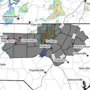
The National Weather Service has issued Severe Thunderstorm Watch 496, which is in effect until 9:00 PM EDT for Davidson County.
A Severe Thunderstorm Watch means that weather conditions are favorable for the development of severe thunderstorms. It does not mean severe weather is occurring everywhere within the watch area, but residents should be prepared for storms to develop quickly this afternoon and evening.
Main Threats
Storms that become severe may produce:
- Damaging wind gusts of 58 mph or greater
- Frequent cloud-to-ground lightning
- Torrential rainfall that may cause localized flooding
- Small hail
Damaging winds remain the primary concern with today's storms.
What You Should Do
Now is a good time to review your severe weather plan and make sure you have multiple ways to receive weather warnings, especially if you have outdoor plans this afternoon or evening.
If a Severe Thunderstorm Warning is issued for your location, move indoors immediately and stay away from windows until the storm passes.
Rowan and Davie Counties
At this time, Rowan and Davie counties are not included in Severe Thunderstorm Watch 496. However, both counties remain under a Slight Risk (Level 2 of 5) for severe thunderstorms today, and storms capable of producing damaging winds remain possible this afternoon and evening.
Rowan County Weather will continue to monitor conditions across Rowan, Davie, and Davidson counties and provide updates if additional watches or warnings are issued.