National Hurricane Center Monitoring Two Areas in the Atlantic Basin
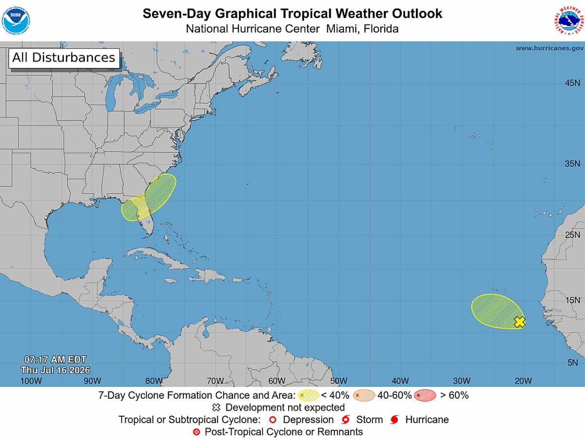
The National Hurricane Center (NHC) is monitoring two areas for possible tropical development, but neither system currently poses an immediate threat to North Carolina.
Tropical Wave in the Eastern Atlantic
The first area of interest is a tropical wave located southeast of the Cabo Verde Islands in the eastern Atlantic Ocean.
While showers and thunderstorms continue to accompany the wave, the system remains disorganized. The National Hurricane Center says some slow development is possible over the next day or two as it moves west-northwest at around 10 mph. However, environmental conditions are expected to become less favorable by this weekend, limiting any additional strengthening.
Current development chances are:
- 10% chance of tropical development during the next 48 hours
- 10% chance of tropical development over the next seven days
At this time, this system is expected to remain over the open Atlantic and does not present any concerns for the Carolinas.
Gulf System Worth Watching
The second area of interest is closer to home.
Forecasters expect an area of low pressure to develop this weekend over the northeastern Gulf. The system is forecast to move slowly northeastward across the Gulf before approaching or moving near the southeastern United States early next week.
Development is expected to be gradual, and the National Hurricane Center currently assigns only a:
- Near 0% chance of development during the next 48 hours
- 20% chance of tropical development during the next seven days
While those odds remain low, this is the system Rowan County residents should keep an eye on over the coming days.
What Could This Mean for North Carolina?
Even if the system never becomes a named tropical storm, it could still transport additional Gulf and Atlantic moisture into portions of the Southeast.
For Rowan County, the forecast already calls for increasing chances of showers and thunderstorms beginning this weekend as a cold front approaches. If the Gulf system develops or moves farther north than currently expected, it could enhance rainfall across parts of the Carolinas next week. However, there is still considerable uncertainty regarding the exact track, timing, and strength of the system.
At this point, there is no indication of a direct tropical threat to Rowan County.
The Bottom Line
The Atlantic Basin remains relatively quiet, with only two areas being monitored by the National Hurricane Center.
The eastern Atlantic tropical wave is expected to remain weak and move into an unfavorable environment, while the Gulf system has only a low chance of development over the next week.
I'll continue monitoring both systems closely. If development chances increase or the forecast begins to indicate any impacts for North Carolina, I'll provide updates here on Rowan County Weather.