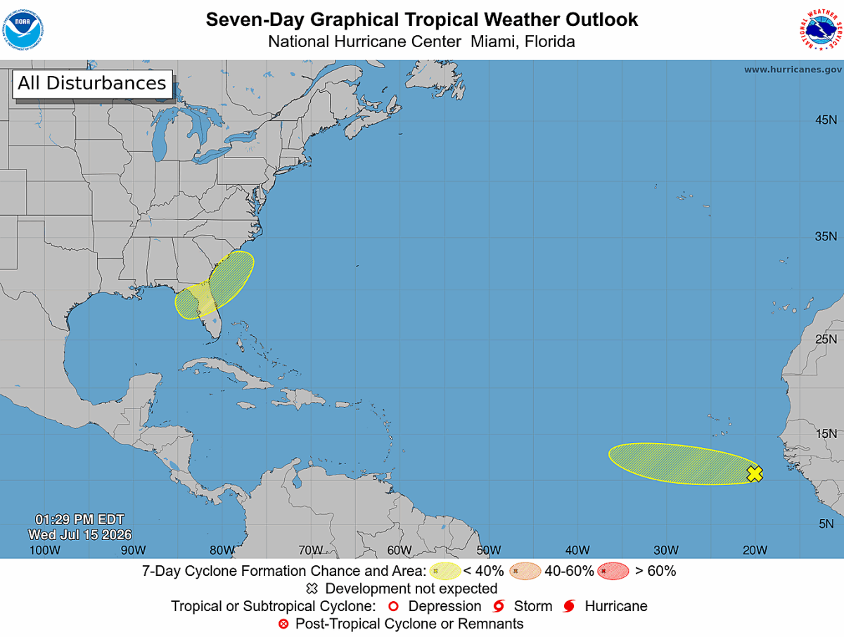
National Hurricane Center Monitoring Two Areas for Possible Tropical Development
The National Hurricane Center is keeping an eye on two separate areas of disturbed weather across the Atlantic Basin. While neither system is expected to develop quickly, both will be monitored over the coming days as hurricane season continues.
At this time, development chances remain low for both areas, and there are no immediate threats to North Carolina.
Northeastern Gulf
The first area of interest is expected to develop this weekend over the northeastern Gulf as an area of low pressure forms.
Forecast models indicate the system will move slowly northeastward across the northeastern Gulf or near the southeastern United States coastline early next week. Some gradual development is possible during that time, but environmental conditions are only marginally favorable.
Current development chances are:
- Next 48 hours: Near 0%
- Next 7 days: 20%
While this system bears watching, the National Hurricane Center continues to classify the potential for development as low.
Eastern Tropical Atlantic
The second area of interest is a tropical wave located southeast of the Cabo Verde Islands in the eastern tropical Atlantic.
Satellite imagery shows showers and thunderstorms have become a little better organized over the past 24 hours. Slow development remains possible during the next couple of days as the wave moves west-northwestward.
However, by this weekend, the disturbance is expected to encounter less favorable atmospheric conditions that should limit any additional strengthening.
Current development chances are:
- Next 48 hours: 10%
- Next 7 days: 10%
No Threat to North Carolina
Neither system poses a threat to North Carolina at this time.
The Gulf disturbance remains in the early stages of development, while the tropical wave is thousands of miles away over the eastern Atlantic. It is far too early to determine whether either system will eventually develop into a tropical depression or tropical storm.
Hurricane Season Is Becoming More Active
As we move deeper into July, it is common to see tropical waves emerging from Africa while areas of low pressure occasionally develop over the Gulf.
Most of these disturbances never become named storms, but they serve as reminders that the Atlantic hurricane season is beginning to become more active.
I'll continue monitoring both systems and provide updates if either shows signs of becoming better organized or if forecast confidence changes in the days ahead.