

Storm Risk Increases Across Southern Rowan County Today
The Storm Prediction Center has placed all of Rowan County under a risk for severe thunderstorms today, but the level of that risk depends on where you are in the county.
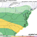
The latest outlook shows northern Rowan County remains in a Level 1 of 5 Marginal Risk, while southern Rowan County has been upgraded to a Level 2 of 5 Slight Risk for severe weather this afternoon and evening.
The primary reason for the higher risk across southern Rowan County is its closer proximity to the environment expected to support stronger thunderstorms as they develop over the western Carolinas and move east.
What Does This Mean?
A Marginal Risk (Level 1 of 5) means isolated severe thunderstorms are possible. Most storms will remain below severe limits, but a few could produce damaging wind gusts or small hail.
A Slight Risk (Level 2 of 5) indicates scattered severe thunderstorms are possible. While it does not mean severe weather is expected everywhere, the coverage of stronger storms is expected to be greater than in the Marginal Risk area.
Wind Is the Main Concern
The Storm Prediction Center's wind outlook also highlights the north-to-south difference across Rowan County.
- Northern Rowan County: 5% chance of damaging thunderstorm winds within 25 miles of any given location.
- Southern Rowan County: 15% chance of damaging thunderstorm winds within 25 miles of any given location.
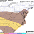
That means residents across southern portions of the county—including areas near China Grove, Landis, Kannapolis, Enochville, and Faith—have a higher potential of seeing storms capable of producing wind gusts of 58 mph or greater.
Timing
Storms are expected to develop during the afternoon, with the greatest potential for Rowan County occurring between 3 PM and 9 PM. Not everyone will see a storm, but any thunderstorm that develops could quickly become strong.
Primary Threats
- Damaging wind gusts capable of downing tree limbs and causing isolated power outages.
- Torrential rainfall leading to localized flooding in poor drainage areas.
- Frequent cloud-to-ground lightning.
- Small hail cannot be ruled out, but wind remains the primary concern.
Stay Weather Aware
The atmosphere will remain unstable through this evening, and storm development will depend on where boundaries from earlier showers set up. This means storms may develop quickly with little warning.
I'll be monitoring conditions throughout the afternoon and evening and will provide radar updates and any watches or warnings that are issued for Rowan County as storms begin to develop.