

Strong Thunderstorms Moving Across Central North Carolina Through 5:00 PM
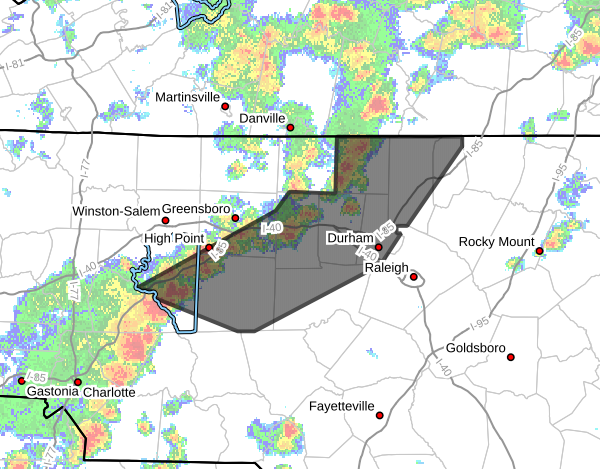
The National Weather Service is tracking a line of strong thunderstorms moving across portions of central North Carolina this afternoon. These storms are expected to impact parts of the region through 5:00 PM EDT.
At 4:01 PM, Doppler radar indicated a cluster of strong thunderstorms extending from near Alton southwest through Graham and east of High Rock Lake, moving east at 25 mph.
While these storms are not currently severe warned, they are capable of producing:
- Wind gusts up to 50 mph
- Frequent lightning
- Heavy rainfall
- Reduced visibility in heavier downpours
Wind gusts of this strength could knock down tree limbs and blow around unsecured outdoor objects. Drivers should also be prepared for sudden reductions in visibility as heavy rain moves through.
Communities that may be impacted include:
- Greensboro
- Durham
- High Point
- Chapel Hill
- Burlington
- Asheboro
- Lexington
- Graham
- Oxford
- Roxboro
The storms are also expected to affect travel along portions of Interstates 40, 73, 74, and 85, as well as the Durham Freeway.
If you are outdoors, move inside a sturdy building until the storms pass. Lightning can strike well ahead of the rain, making outdoor activities dangerous even before the heaviest precipitation arrives.
I will continue monitoring these storms and provide updates if they strengthen or if any additional warnings are issued for the affected areas.