Rowan County Forecast: Hot Today, Cooler Weather Ahead with Increasing Storm Chances
After several days of intense summer heat, we're finally beginning to see some changes in the forecast. Today will be another hot and humid day, but temperatures will gradually trend downward through the weekend, with much cooler-than-normal weather arriving by Monday. Along with the cooler air comes a much more active weather pattern, bringing daily opportunities for showers and thunderstorms.
Today's Forecast
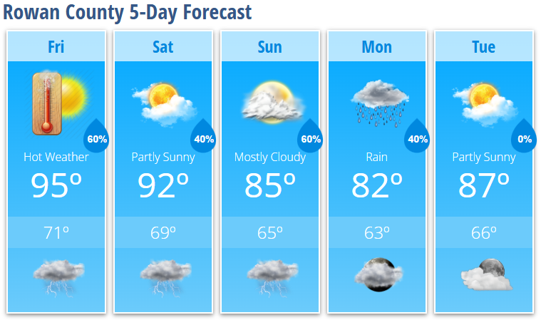
Expect increasing clouds with a high near 95° this afternoon. While today's heat won't be quite as intense as earlier this week, it will still feel uncomfortable if you're spending time outdoors. Be sure to stay hydrated and take frequent breaks.
Scattered showers and thunderstorms will begin developing this afternoon, becoming more numerous between 4 PM and 5 PM before gradually becoming scattered again this evening. Rain chances are 60%, and while many locations won't see rain, any storm that develops could produce heavy downpours, gusty winds, frequent lightning, and isolated hail.
Tonight will remain mostly cloudy with a low around 71°. A few showers or thunderstorms may redevelop late tonight into the pre-dawn hours.
Saturday
Saturday won't be quite as hot, with afternoon highs around 92°. Much of the day will stay dry, but another round of scattered showers and thunderstorms is expected late in the afternoon and evening. Rain chances are 30% during the day, increasing to 40% Saturday night.
Sunday Into Monday
Sunday marks the beginning of a noticeable pattern change. High temperatures will only reach the mid-80s, making it the coolest day we've experienced in about two weeks.
Showers and thunderstorms become more widespread Sunday afternoon and continue Sunday night. Rain chances remain 60%, with additional showers lingering into Monday. Highs Monday may struggle to get much above 82°, nearly 10 degrees below average for mid-July.
Some storms through Monday could become strong, producing damaging wind gusts, while repeated rounds of heavy rain may lead to localized flooding in poor drainage areas.
Looking Ahead
Conditions gradually improve Tuesday with a mix of clouds and sunshine and a high around 87°. Temperatures should slowly return to more typical July levels during the middle of next week.
Rowan County Weather Summary
- One more hot day today with highs around 95°.
- Daily storm chances continue through Monday, with the greatest coverage expected Sunday into Monday.
- A few storms could produce gusty winds, frequent lightning, and torrential rainfall.
- Localized flooding will be possible where storms repeatedly move over the same locations.
- A refreshing cooldown arrives Sunday and Monday, with highs falling into the mid-80s Sunday and lower 80s Monday.
I'll be keeping a close eye on radar trends through the afternoon and evening and will provide updates if stronger storms begin developing or any warnings are issued for Rowan County.