Davie County Forecast: Hot Through Saturday, Cooler Air Moves In Early Next Week
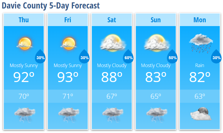
Summer heat will remain in place across Davie County through Saturday, with afternoon temperatures climbing into the lower 90s. Only isolated to scattered afternoon and evening thunderstorms are expected today and Friday, but rain chances increase significantly over the weekend as a cold front approaches.
That front will finally bring relief from the heat beginning Sunday, with much cooler temperatures settling into the area by Monday. Highs early next week will be around the lower 80s, a welcome change after several days of summer heat.
Today
Expect increasing clouds with a hot afternoon. Highs will reach around 92°. A 30% chance of showers and thunderstorms develops after 4 PM, with many locations staying dry.
Tonight
Any isolated evening storms will quickly come to an end, leaving partly cloudy skies overnight. Low temperatures will settle near 70°.
Friday
Another hot summer day is on tap with mostly sunny skies and a high near 93°. A 30% chance of showers and thunderstorms returns after 3 PM, with a few storms capable of producing gusty winds.
Friday Night
Any evening thunderstorms will fade after sunset. Skies become partly cloudy overnight with a low around 71°.
Saturday
Clouds increase ahead of an approaching cold front. High temperatures cool slightly to around 88°, while shower and thunderstorm chances increase during the afternoon and evening. Rain chances climb to 60% after 4 PM.
Saturday Night
Showers and thunderstorms remain likely through the evening before gradually decreasing overnight. Low temperatures fall to around 67°.
Sunday
The cold front moves into the region, bringing another round of scattered showers and thunderstorms. Expect mostly cloudy skies with a high near 83° and a 50% chance of rain.
Sunday Night
A few showers and thunderstorms may linger into the evening before slowly tapering off. Overnight low around 65°.
Monday
Noticeably cooler air arrives across Davie County. There remains a 30% chance of a lingering shower early in the day, otherwise expect partly sunny skies with a high near 82°.
What Has Changed?
- No significant changes to the overall forecast.
- Morning fog and low clouds were removed after they failed to develop overnight.
Key Messages
- Hot and humid conditions continue through Saturday with highs in the lower 90s.
- Isolated afternoon and evening thunderstorms remain possible today and Friday.
- A few stronger storms Friday and Saturday could produce damaging wind gusts.
- Rain and thunderstorm coverage increases this weekend as a cold front moves through the area.
- Much cooler air settles into the region Sunday through Tuesday, with highs dropping into the lower 80s by Monday.