Davidson County Forecast: Hot Friday Before Weekend Storm Chances Increase
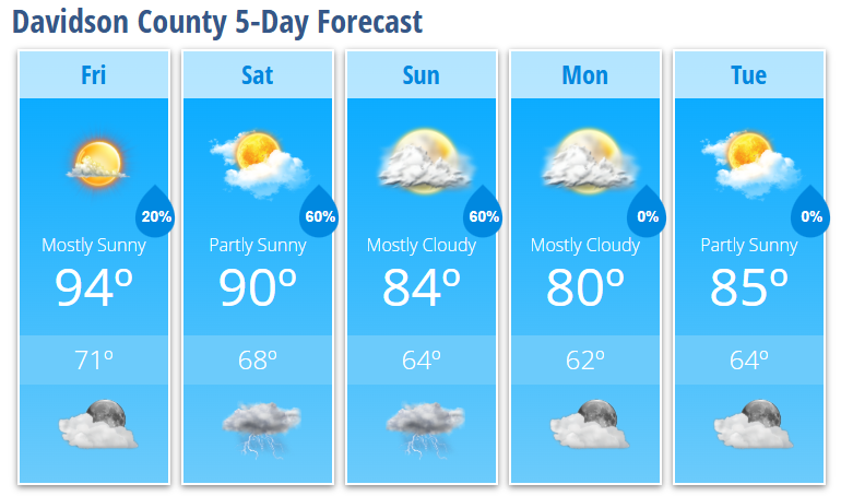
Summer heat sticks around for one more day before the weather pattern becomes much more active this weekend. Friday will be hot with only a slight chance of an afternoon thunderstorm, but rain and thunderstorm coverage increases significantly Saturday and Sunday as a cold front approaches the Carolinas.
Behind that front, cooler-than-normal temperatures arrive early next week, providing a welcome break from the recent heat.
Friday
Expect mostly sunny skies with a high near 94°. A light west breeze develops during the afternoon. Only a 20% chance of showers and thunderstorms is expected after 2 PM, so most of Davidson County will stay dry.
Friday Night
Any isolated evening shower or thunderstorm will quickly come to an end. Skies become partly cloudy before more clouds move in late. Overnight low around 71°.
Saturday
It will remain warm with a high near 90°. Expect a mix of sun and clouds before showers and thunderstorms become likely late in the day, especially after 5 PM. Rain chances increase to 60%, and a few storms could produce gusty winds and heavy downpours.
Saturday Night
Showers and thunderstorms remain likely through the evening before gradually tapering overnight. Low temperatures fall to around 68°.
Sunday
Sunday continues to look like the wettest day of the forecast. Mostly cloudy skies are expected with a high near 84°. Showers and thunderstorms become likely during the afternoon, with rain chances remaining at 60%.
Sunday Night
Showers and thunderstorms continue through the evening before gradually decreasing overnight. Low temperatures settle near 64°.
Monday
Mostly cloudy and much cooler with a high near 80°, making it the coolest day of the forecast.
Monday Night
Mostly cloudy with a low around 62°.
Tuesday
Partly sunny skies return with a pleasant high near 85°.
What Has Changed?
- No significant changes have been made to the overall forecast.
- Saturday and Sunday continue to offer the highest chances for widespread showers and thunderstorms.
Key Messages
- Friday remains hot with highs in the mid-90s.
- Only isolated thunderstorms are expected Friday, with most locations remaining dry.
- Shower and thunderstorm coverage increases significantly this weekend, especially Saturday evening and Sunday.
- A few storms this weekend could produce gusty winds and locally heavy rainfall.
- Cooler air settles into Davidson County Monday, with highs dropping to around 80° before gradually warming again later next week.