Rowan County Forecast: Hot Through Saturday, Better Rain Chances This Weekend
Good evening! Summer weather continues across Rowan County for the next few days with afternoon heat, humidity, and isolated thunderstorms. A cold front arriving this weekend will bring a better chance for showers and thunderstorms before ushering in cooler temperatures for Sunday and Monday.
Thursday
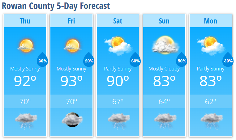
Expect mostly sunny skies with a high near 92°. It will remain warm and humid, with a 30% chance of showers and thunderstorms after 5 PM. While many locations will stay dry, any storm that develops could produce gusty winds, frequent lightning, and brief heavy rainfall.
Thursday night will be mostly clear with a 30% chance of a lingering thunderstorm before 8 PM before skies clear. Overnight lows fall to around 70°.
Friday
Friday looks very similar with a mix of sun and clouds and a high around 93°. Only a 20% chance of an afternoon thunderstorm is expected after 3 PM, so most of the day will remain dry.
Friday night will be partly to mostly cloudy with a slight chance of an evening shower or thunderstorm and a low near 70°.
Weekend Outlook
Saturday will be the transition day as a cold front approaches the Carolinas.
Expect partly sunny skies with a high near 90°, but rain chances increase significantly during the afternoon and evening. Showers and thunderstorms become likely after 4 PM with a 60% chance of rain. Some storms could become strong, with damaging wind gusts remaining the primary hazard.
Showers and thunderstorms continue Saturday night before gradually decreasing after midnight.
Cooler Weather Arrives
The cold front settles south of the area on Sunday, bringing noticeably cooler temperatures.
- Sunday: Mostly cloudy with a high near 83° and a 50% chance of afternoon showers and thunderstorms.
- Monday: Partly sunny with a high near 83° and a 30% chance of showers and thunderstorms.
This will be the coolest stretch of weather we've experienced in quite some time and should provide a welcome break from the recent heat.
What I'm Watching
- Seasonably hot afternoons continue through Saturday, with highs in the lower 90s.
- Isolated afternoon and evening thunderstorms remain possible Thursday and Friday, with damaging wind gusts the main concern in any stronger storm.
- The best chance for widespread showers and thunderstorms arrives Saturday afternoon through Sunday as a cold front moves through.
- Cooler temperatures settle in for Sunday and Monday, with highs dropping into the lower 80s and more comfortable conditions expected.
If you'll be spending time outdoors over the next few days, continue practicing heat safety by staying hydrated, taking breaks in the shade, and keeping an eye on the sky during the afternoon. I'll continue monitoring storm development and provide updates if stronger storms develop across Rowan County.