Davidson County Forecast: Hot Through Saturday, Higher Rain Chances This Weekend
Good evening! Summer weather remains in full swing across Davidson County through the end of the workweek with warm temperatures, afternoon thunderstorm chances, and increasing humidity. A cold front arriving this weekend will bring a better opportunity for widespread rain before cooler temperatures settle in for Sunday and Monday.
Thursday
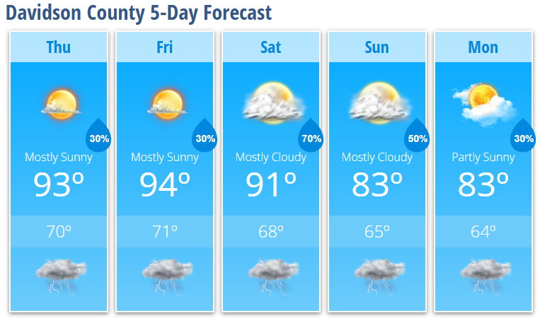
Expect mostly sunny skies with a high near 93°. A 30% chance of showers and thunderstorms develops after 5 PM, although many locations will remain dry. Any storm that forms could produce gusty winds, frequent lightning, and brief heavy rainfall.
Thursday night will be mostly clear with a 30% chance of showers and thunderstorms before 8 PM, followed by a low around 70°.
Friday
Friday will be another warm summer day with mostly sunny skies and a high near 94°. A 30% chance of afternoon and evening thunderstorms develops after 2 PM, with most activity remaining scattered.
Friday night stays mostly cloudy with a slight chance of an evening thunderstorm and a low around 71°.
Weekend Forecast
Rain chances increase noticeably this weekend as a cold front approaches.
Saturday will be mostly cloudy with a high near 91°. Showers and thunderstorms become likely after 2 PM, with a 70% chance of rain through the afternoon and evening. Some storms could become strong, with damaging wind gusts remaining the primary severe weather threat.
Showers and thunderstorms continue Saturday night before gradually diminishing after midnight.
Cooler Weather Returns
The cold front moves through on Sunday, bringing cooler temperatures and a break from the recent heat.
- Sunday: Mostly cloudy with a high near 83° and a 50% chance of afternoon showers and thunderstorms.
- Monday: Partly sunny with a high near 83° and a 30% chance of showers and thunderstorms.
This will be the coolest stretch of weather we've experienced in over a week and should make it much more comfortable for outdoor activities.
What I'm Watching
- Hot afternoons continue through Saturday, with highs in the lower 90s.
- Scattered afternoon and evening thunderstorms remain possible Thursday and Friday.
- A few stronger storms could produce damaging wind gusts.
- Rain chances increase significantly Saturday and Sunday as a cold front moves through the region.
- Cooler temperatures arrive for Sunday and Monday, with highs dropping into the lower 80s and lower humidity returning.
If you'll be outdoors over the next few days, continue practicing heat safety by staying hydrated, taking breaks from the heat, and keeping an eye on the sky during the afternoon hours. I'll continue monitoring the forecast and provide updates if stronger storms develop across Davidson County.