Davidson County Forecast: Hot Through Friday, Wetter Weekend Brings Much Needed Relief
Good Wednesday morning! Davidson County has a few more days of typical midsummer weather ahead, with hot afternoons, isolated thunderstorms, and plenty of humidity. A more noticeable pattern change arrives this weekend as a cold front increases rain chances and brings significantly cooler temperatures by Sunday.
Today's Forecast
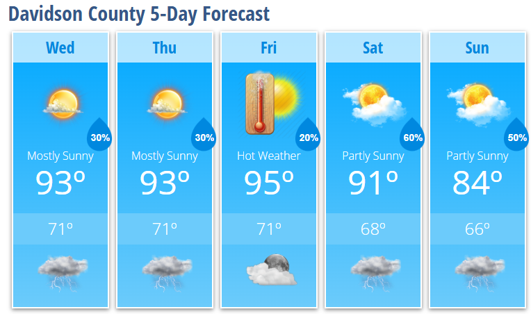
Expect mostly sunny skies with a high near 93° this afternoon. While the hottest heat will remain farther south and east of the county, it will still feel quite warm with humid conditions. There is a 20% chance of an isolated shower or thunderstorm after 3 PM, with any storm capable of producing brief heavy rain, gusty winds, and frequent lightning.
Tonight brings a 30% chance of showers and thunderstorms before 11 PM, followed by partly cloudy skies and a low around 71°.
Thursday and Friday
Little changes through the end of the workweek.
- Afternoon highs remain in the lower to middle 90s.
- Only isolated afternoon and evening thunderstorms are expected, with 20–30% rain chances.
- Most of the county will remain dry each day, but any storm that develops could produce gusty winds and locally heavy rainfall.
Weekend Forecast
Saturday marks the beginning of a wetter weather pattern.
- High temperatures ease back to around 91°.
- Rain chances increase to 70% during the afternoon and evening as a cold front approaches.
- Several rounds of showers and thunderstorms are possible, with locally heavy rainfall and gusty winds.
By Sunday, cooler air begins working into the area.
- High temperatures fall to around 84°.
- Rain chances remain at 50%, especially during the afternoon.
- Humidity levels will begin dropping, making it feel much more comfortable than it has over the past week.
Looking Ahead
The prolonged stretch of above-normal heat is finally coming to an end. Early next week is expected to feature cooler temperatures, lower humidity, and much more comfortable conditions across Davidson County.
What I'm Watching
- Hot afternoons continue through Friday, with highs in the lower to middle 90s.
- Isolated afternoon storms remain possible through the end of the workweek.
- The best opportunity for widespread rainfall arrives Saturday afternoon through Sunday.
- Cooler temperatures and lower humidity return by Sunday and continue into early next week.
If you'll be spending time outdoors, continue practicing heat safety by staying hydrated, taking frequent breaks, and checking on those who are more vulnerable to the heat. Cooler weather is finally on the way after another couple of hot summer days.