Rowan County Forecast: Hot Summer Pattern Continues with Daily Storm Chances
After Sunday's scattered thunderstorms, Rowan County will remain locked into a typical midsummer weather pattern this week. Expect hot afternoons, warm and humid nights, and daily opportunities for showers and thunderstorms, with the best chances continuing through Tuesday.
Monday: Hot with Only Isolated Afternoon Storms
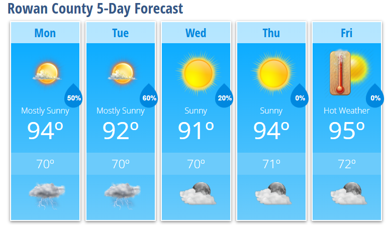
Monday will feature plenty of sunshine and another hot afternoon, although temperatures will be slightly cooler than what we've experienced over the past several days.
High temperatures will reach 94 degrees, while the heat index climbs to around 100 degrees during the afternoon.
Most of the day will remain dry, but a few isolated showers and thunderstorms could develop after 2 PM. Rain coverage is expected to remain limited during the afternoon before increasing during the evening.
Monday night brings a 50% chance of showers and thunderstorms, mainly before 2 AM.
Tuesday: Highest Rain Chances of the Week
Tuesday currently appears to be the most active weather day of the forecast period.
After a warm and partly sunny start, showers and thunderstorms are expected to become more numerous during the afternoon, especially after 5 PM.
High temperatures will top out near 92 degrees, with a 60% chance of showers and thunderstorms by late afternoon and evening.
Some storms could become strong, producing:
- Damaging wind gusts
- Frequent lightning
- Heavy downpours
- Localized flooding in poor drainage areas
Midweek Brings a Brief Break
Storm coverage decreases on Wednesday, although an isolated afternoon thunderstorm remains possible.
Wednesday's forecast includes:
- Mostly sunny skies
- High near 91 degrees
- Only a 20% chance of an afternoon storm
Thursday looks even quieter, with mostly sunny skies and highs returning to the middle 90s.
Hotter Weather Returns Late Week
By Friday, temperatures climb back into the mid-90s, with plenty of sunshine expected.
While Friday currently looks dry, forecasters are watching an increasingly unsettled weather pattern developing late this week and into next weekend.
Looking Ahead
Forecast confidence begins to decrease during the second half of the week.
Several weather disturbances may move through the Carolinas beginning Thursday and continuing into next weekend. Unlike the typical afternoon "pop-up" storms we've seen recently, these systems could bring more widespread showers and thunderstorms at times.
Forecasters are also monitoring the potential for storms to become better organized later this week, as stronger winds higher in the atmosphere may support more organized thunderstorm development than we've experienced over the past several days.
Bottom Line
- Highs remain in the lower to middle 90s all week.
- Heat index values will approach 100 degrees each afternoon.
- Isolated storms are expected Monday, with the highest rain chances arriving Tuesday.
- A few storms through Tuesday could produce damaging wind gusts.
- The weather pattern may become more active and unsettled later this week with additional opportunities for showers and thunderstorms.
If you have outdoor plans this week, continue to practice heat safety, stay hydrated, and keep an eye on the forecast each afternoon, as thunderstorms can develop quickly in the summer heat. I'll continue monitoring conditions and provide updates throughout the week as needed.